


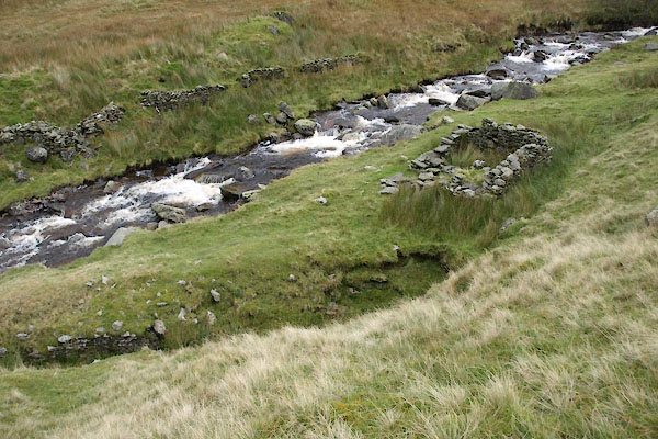
BXM63.jpg (taken 12.10.2012)
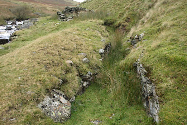
BXM64.jpg (taken 12.10.2012)
"Old Lead Mine"
placename:- Glenderaterra Mine
item:- galena; cerussite; copper pyrites; chrysocolla; barytes; lead ore; copper ore
 goto source
page 101:- "THE GLENDERATERRA MINE."
"The Glenderaterra Valley has been formed by the great fault which runs through the length of Windermere, Rydal, Grasmere and Thirlmere Lakes. At or near the foot of Thirlmere it divides into two branches, one passing along the Vale of St. John, and the other one along the Vale of Naddle. In the Glenderaterra Valley the fault is represented by two, three, or possibly more separate parallel fissures, which since they were formed have become mineral veins. The ores which these veins yield are galena, cerussite, chalcopyrite, chrysocollo, and barytes."
"Miners commenced operations in the Glenderaterra Valley moderately early, and the most northerly works were probably the earliest, the first being a level driven northward on a vein on the eastern side of the stream (Glenderaterra BecK), and the out-"
 goto source
page 103:- "[out]put of ore here seems to have been mostly copper. Another level was commenced and was driven northward on another vein, just a little lower down, and on the western side of the stream. Some good ore was no doubt found here, and after heading it out to the surface, a shaft was sunk some depth below the sole of the adit level, and then it was abandoned. This much could be learned from the old workings."
"About the years 1849 or 1850, J. Crosier, of the Riddings, Threlkeld, J. Richardson, of Cockermouth, and other local gentlemen, of whom the author's father was one, sunk a shaft on what is probably another vein, on the eastern side of the stream. This shaft was sunk probably to a depth of 20 or 25 fathoms, and a considerable quantity of ore was obtained from it, but the failure in business, from other causes than mining, of one of the principal partners, caused the work to be suspended, and ultimately brought it to an end. Some twenty years later, William Porter, of Threlkeld, commenced working in the northern shaft, under the supervision of Col. Watson, who afterwards took the mine into his own hands, and employed a London Firm of Mining Engineers to direct and superintend the work. The shaft was sunk to a depth of 30 fathoms and levels were driven off north and south at 20 and 30 fathoms from the surface. Some efforts were then made to form a Company to continue the work, but these efforts were rendered abortive, owing to the high price demanded by the Engineers."
"After an interval of well on to forty years the mine was again opened by a Company of local gentlemen, who pushed on the levels previously opened by Col. Watson, chiefly in a southerly direction, and found a good run of ore about 40 fathoms south of the shaft. A rise had been worked up in this part of the mine from the 30 fathom level, through and above the 20 fathom level, and good stoping ground has been opened, but dressing machinery is needed before work can be carried further."
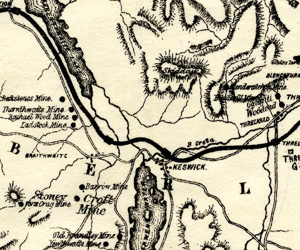
placename:- Glenderaterra Mine
PST2NY22.jpg
"[Glenderaterra Mine]"
mine symbol
item:- JandMN : 162.2
Image © see bottom of page
placename:- Glenderaterra Mine
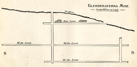 click to enlarge
PST322.jpg
On p.102 of Mines and Mining in the English Lake District, by John Postlethwaite.
printed, upper right "GLENDERATERRA MINE. / Scale 10 Fms. to 1 inch"
item:- JandMN : 162.24
Image © see bottom of page
placename:- Glenderaterra Mine
item:- galena; cerussite; copper pyrites; chrysocolla; barytes; lead ore; copper ore
 goto source
page 101:- "THE GLENDERATERRA MINE."
"The Glenderaterra Valley has been formed by the great fault which runs through the length of Windermere, Rydal, Grasmere and Thirlmere Lakes. At or near the foot of Thirlmere it divides into two branches, one passing along the Vale of St. John, and the other one along the Vale of Naddle. In the Glenderaterra Valley the fault is represented by two, three, or possibly more separate parallel fissures, which since they were formed have become mineral veins. The ores which these veins yield are galena, cerussite, chalcopyrite, chrysocollo, and barytes."
"Miners commenced operations in the Glenderaterra Valley moderately early, and the most northerly works were probably the earliest, the first being a level driven northward on a vein on the eastern side of the stream (Glenderaterra BecK), and the out-"
 goto source
page 103:- "[out]put of ore here seems to have been mostly copper. Another level was commenced and was driven northward on another vein, just a little lower down, and on the western side of the stream. Some good ore was no doubt found here, and after heading it out to the surface, a shaft was sunk some depth below the sole of the adit level, and then it was abandoned. This much could be learned from the old workings."
"About the years 1849 or 1850, J. Crosier, of the Riddings, Threlkeld, J. Richardson, of Cockermouth, and other local gentlemen, of whom the author's father was one, sunk a shaft on what is probably another vein, on the eastern side of the stream. This shaft was sunk probably to a depth of 20 or 25 fathoms, and a considerable quantity of ore was obtained from it, but the failure in business, from other causes than mining, of one of the principal partners, caused the work to be suspended, and ultimately brought it to an end. Some twenty years later, William Porter, of Threlkeld, commenced working in the northern shaft, under the supervision of Col. Watson, who afterwards took the mine into his own hands, and employed a London Firm of Mining Engineers to direct and superintend the work. The shaft was sunk to a depth of 30 fathoms and levels were driven off north and south at 20 and 30 fathoms from the surface. Some efforts were then made to form a Company to continue the work, but these efforts were rendered abortive, owing to the high price demanded by the Engineers."
"After an interval of well on to forty years the mine was again opened by a Company of local gentlemen, who pushed on the levels previously opened by Col. Watson, chiefly in a southerly direction, and found a good run of ore about 40 fathoms south of the shaft. A rise had been worked up in this part of the mine from the 30 fathom level, through and above the 20 fathom level, and good stoping ground has been opened, but dressing machinery is needed before work can be carried further."
placename:- Glenderaterra Mine

PST2NY22.jpg
"[Glenderaterra Mine]"
mine symbol
item:- JandMN : 162.2
Image © see bottom of page
placename:- Glenderaterra Mine
 click to enlarge
PST322.jpg
On p.102 of Mines and Mining in the English Lake District, by John Postlethwaite.
printed, upper right "GLENDERATERRA MINE. / Scale 10 Fms. to 1 inch"
item:- JandMN : 162.24
Image © see bottom of page
placename:- Glenderaterra Mines
item:- galena; malachite; copper pyrites; azurite; pyromorphite
Geological Outing of the Kendal and District Mine Research Society
Log book page 5:- "DATE - 13/4/79 FRIDAY (EASTER HOLIDAYS) / MAP REF - NY22 2950 2740 / LOCATION - GLENDERATERRA VALLEY / NAME - GLENDERATERRA MINES / TYPE OF SITE - MINES / WORKING OR DISUSED - DISUSED / PEOPLE IN PARTY [ ] / NOS. OF PHOTOS - NONE / SPECIMENS FOUND - SMALL PIECES OF GALENA, MALACHITE, COPPER PYRITES AND AZURITE + PYROMORPHITE / COMMENTS - NICE DRY DAY, SLIGHT WIND, COVERED ABOUT 2½MILES. (APPROX). UNFORTUNATELY NO LEVELS LEFT OPEN TO ENTER ."
item:- private collection : 82
Image © see bottom of page
placename:- Glenderaterra Mine
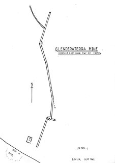 click to enlarge
KMR20.jpg
"GLENDERATERRA MINE"
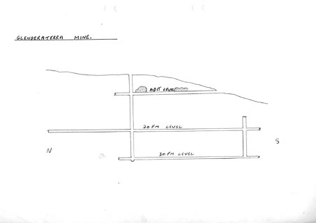 click to enlarge
KMR21.jpg
"GLENDERATERRA MINE"
item:- private collection : 82
Image © see bottom of page
