 Old Cumbria Gazetteer
 |
 |
|
| Crag Hill, Dent | ||
| Crag Hill | ||
| civil parish:- | Dent (formerly Yorkshire) | |
| civil parish:- | Barbon (formerly Westmorland) | |
| civil parish:- | Casterton (formerly Westmorland) | |
| county:- | Cumbria | |
| locality type:- | hill | |
| locality type:- | boundary feature | |
| locality type:- | parish boundary feature | |
| locality type:- | county boundary feature (old) | |
| coordinates:- | SD69218331 (etc) | |
| 1Km square:- | SD6983 | |
| 10Km square:- | SD68 | |
|
|
||
| evidence:- | old map:- OS County Series (Wmd 44 11) placename:- Crag Hill |
|
| source data:- | Maps, County Series maps of Great Britain, scales 6 and 25
inches to 1 mile, published by the Ordnance Survey, Southampton,
Hampshire, from about 1863 to 1948. |
|
|
|
||
| evidence:- | possibly old map:- Jefferys 1770 (Wmd) placename:- Borrons |
|
| source data:- | Map, 4 sheets, The County of Westmoreland, scale 1 inch to 1
mile, surveyed 1768, and engraved and published by Thomas
Jefferys, London, 1770.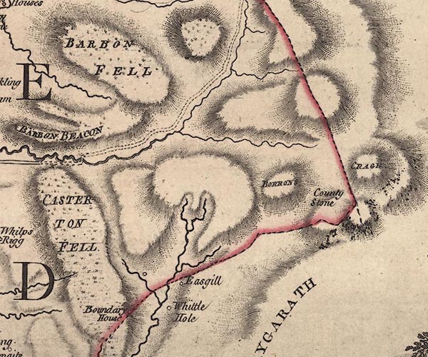 J5SD68SE.jpg "BORRONS" hill hachuring; hill or mountain item:- National Library of Scotland : EME.s.47 Image © National Library of Scotland |
|
|
|
||
 Lakes Guides menu.