 Old Cumbria Gazetteer
 |
 |
|
| Box Holme, Thirlmere | ||
| gone | ||
| Box Holme | ||
| locality:- | Thirlmere | |
| civil parish:- | St John's Castlerigg and Wythburn (formerly Cumberland) | |
| county:- | Cumbria | |
| locality type:- | island (flooded) | |
| coordinates:- | NY310175 (about) | |
| 1Km square:- | NY3117 | |
| 10Km square:- | NY31 | |
|
|
||
| evidence:- | old map:- OS County Series (Cmd 70 4) placename:- Box Holme |
|
| source data:- | Maps, County Series maps of Great Britain, scales 6 and 25
inches to 1 mile, published by the Ordnance Survey, Southampton,
Hampshire, from about 1863 to 1948. |
|
|
|
||
| evidence:- | old print:- Harwood 1895 placename:- Box Holme Island |
|
| source data:- | Print, halftone photograph, Thirlmere looking North, Box Holme Island, and Raven Crag,
Cumberland, probably by Meisenbach, published by Henry Blacklock and Co, Albert Square,
Manchester, 1895.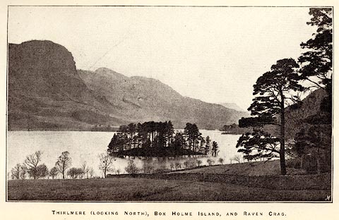 click to enlarge click to enlargeHRW309.jpg Tipped in opposite p.58 of the History and Description of the Thirlmere Water Scheme, by Sir John James Harwood. printed at bottom:- "THIRLMERE (LOOKING NORTH), BOX HOLME ISLAND, AND RAVEN CRAG." printed at lower right:- "M" item:- Armitt Library : A660.11 Image © see bottom of page |
|
|
|
||
 Lakes Guides menu.