 Old Cumbria Gazetteer
 |
 |
|
| Maryport and Carlisle Goods Depot, Carlisle | ||
| Maryport and Carlisle Goods Depot | ||
| site name:- | Maryport and Carlisle Railway | |
| Street:- | Crown Street | |
| locality:- | Botchergate | |
| civil parish:- | Carlisle (formerly Cumberland) | |
| county:- | Cumbria | |
| locality type:- | railway sidings | |
| locality type:- | goods depot | |
| locality type:- | coal depot | |
| coordinates:- | NY40365527 (about) | |
| 1Km square:- | NY4055 | |
| 10Km square:- | NY45 | |
|
|
||
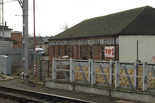 BWA26.jpg "MARYPORT AND CARLISLE RAILWAY GOODS AND COAL DEPOT." (taken 7.3.2012) |
||
|
|
||
| evidence:- | old map:- OS County Series (Cmd 23 7) placename:- Maryport and Carlisle Railway Goods and Coal Depot item:- weighing machine; goods shed |
|
| source data:- | Maps, County Series maps of Great Britain, scales 6 and 25
inches to 1 mile, published by the Ordnance Survey, Southampton,
Hampshire, from about 1863 to 1948. OS County Series (Cmd 23 8) 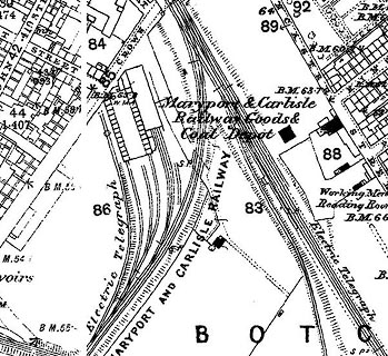 click to enlarge click to enlargeCSRY0040.jpg "Maryport & Carlisle Railway Goods &Coal Depot / W.M. / MARYPORT AND CARLISLE RAILWAY / ..." |
|
|
|
||
 Lakes Guides menu.