 Old Cumbria Gazetteer
 |
 |
|
| Parkside House, Kendal | ||
| Parkside House | ||
| Street:- | Parkside Road | |
| civil parish:- | Kendal (formerly Westmorland) | |
| county:- | Cumbria | |
| locality type:- | buildings | |
| coordinates:- | SD53029206 | |
| 1Km square:- | SD5392 | |
| 10Km square:- | SD59 | |
| references:- | Listed Buildings 2010 |
|
|
|
||
| evidence:- | probably old map:- OS County Series (Wmd 39 5) placename:- Parkside |
|
| source data:- | Maps, County Series maps of Great Britain, scales 6 and 25
inches to 1 mile, published by the Ordnance Survey, Southampton,
Hampshire, from about 1863 to 1948. |
|
|
|
||
| evidence:- | probably old map:- Cary 1789 (edn 1805) placename:- Part House |
|
| source data:- | Map, uncoloured engraving, Westmoreland, scale about 2.5 miles
to 1 inch, by John Cary, London, 1789; edition 1805.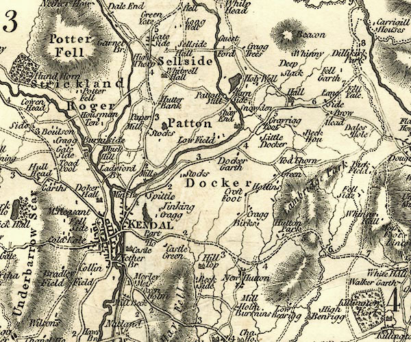 CY24SD59.jpg "Part Ho" block/s, labelled in italic lowercase; house, or hamlet item:- JandMN : 129 Image © see bottom of page |
|
|
|
||
| evidence:- | database:- Listed Buildings 2010 placename:- Parkside House placename:- Parklands |
|
| source data:- | courtesy of English Heritage "PARKSIDE HOUSE AND PARKLANDS / / PARKSIDE ROAD / KENDAL / SOUTH LAKELAND / CUMBRIA / II / 75475 / SD5302392061" |
|
|
|
||
 Lakes Guides menu.