 Old Cumbria Gazetteer
 |
 |
|
| Overwater Hall, Ireby | ||
| Overwater Hall | ||
| civil parish:- | Ireby (formerly Cumberland) | |
| county:- | Cumbria | |
| locality type:- | inn | |
| coordinates:- | NY24343461 | |
| 1Km square:- | NY2434 | |
| 10Km square:- | NY23 | |
| references:- | Listed Buildings 2010 |
|
|
|
||
| evidence:- | old map:- OS County Series (Cmd 47 9) placename:- Whitefield House |
|
| source data:- | Maps, County Series maps of Great Britain, scales 6 and 25
inches to 1 mile, published by the Ordnance Survey, Southampton,
Hampshire, from about 1863 to 1948. |
|
|
|
||
| evidence:- | old map:- Donald 1774 (Cmd) placename:- White Field |
|
| source data:- | Map, hand coloured engraving, 3x2 sheets, The County of Cumberland, scale about 1
inch to 1 mile, by Thomas Donald, engraved and published by Joseph Hodskinson, 29
Arundel Street, Strand, London, 1774.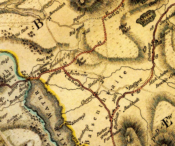 D4NY23SW.jpg "White Field" block or blocks, labelled in lowercase; a hamlet or just a house item:- Carlisle Library : Map 2 Image © Carlisle Library |
|
|
|
||
| evidence:- | database:- Listed Buildings 2010 placename:- Overwater Hall item:- date stone (1911) |
|
| source data:- | courtesy of English Heritage "OVERWATER HALL HOTEL AND GARDEN TERRACE / / / IREBY AND ULDALE / ALLERDALE / CUMBRIA / II / 72429 / NY2434734614" |
|
|
|
||
 Lakes Guides menu.