 Old Cumbria Gazetteer
 |
 |
|
| Low Blakebank, Underbarrow and Bradleyfield | ||
| Low Blakebank | ||
| locality:- | Blakebank | |
| civil parish:- | Underbarrow and Bradleyfield (formerly Westmorland) | |
| county:- | Cumbria | |
| locality type:- | buildings | |
| coordinates:- | SD45649139 | |
| 1Km square:- | SD4591 | |
| 10Km square:- | SD49 | |
|
|
||
| evidence:- | old map:- Jefferys 1770 (Wmd) placename:- Blake Bank |
|
| source data:- | Map, 4 sheets, The County of Westmoreland, scale 1 inch to 1
mile, surveyed 1768, and engraved and published by Thomas
Jefferys, London, 1770.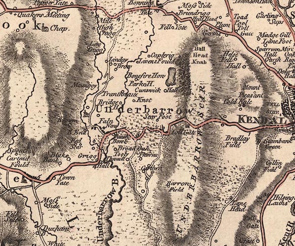 J5SD49SE.jpg "Blake Bank" circle, labelled in italic lowercase text; settlement, farm, house, or hamlet? item:- National Library of Scotland : EME.s.47 Image © National Library of Scotland |
|
|
|
||
| evidence:- | database:- Listed Buildings 2010 placename:- Low Blakebank Farm placename:- Blakebank Farm, Low |
|
| source data:- | courtesy of English Heritage "LOW BLAKEBANK FARMHOUSE / / / UNDERBARROW AND BRADLEYFIELD / SOUTH LAKELAND / CUMBRIA / II / 75307 / SD4564891394" |
|
|
|
||
| evidence:- | database:- Listed Buildings 2010 |
|
| source data:- | courtesy of English Heritage "BARN TO WEST OF LOW BLAKEBANK FARMHOUSE / / / UNDERBARROW AND BRADLEYFIELD / SOUTH LAKELAND / CUMBRIA / II / 75308 / SD4562091399" |
|
|
|
||
 Lakes Guides menu.