 Old Cumbria Gazetteer
 |
 |
|
| Helsfell, Strickland Ketel | ||
| Helsfell | ||
| civil parish:- | Strickland Ketel (formerly Westmorland) | |
| county:- | Cumbria | |
| locality type:- | buildings | |
| coordinates:- | SD49809391 | |
| 1Km square:- | SD4993 | |
| 10Km square:- | SD49 | |
| references:- | Listed Buildings 2010 |
|
|
|
||
| evidence:- | old map:- OS County Series (Wmd 38 3) placename:- Helsfell |
|
| source data:- | Maps, County Series maps of Great Britain, scales 6 and 25
inches to 1 mile, published by the Ordnance Survey, Southampton,
Hampshire, from about 1863 to 1948. |
|
|
|
||
| evidence:- | old map:- Jefferys 1770 (Wmd) placename:- Helse Fell Hall |
|
| source data:- | Map, 4 sheets, The County of Westmoreland, scale 1 inch to 1
mile, surveyed 1768, and engraved and published by Thomas
Jefferys, London, 1770.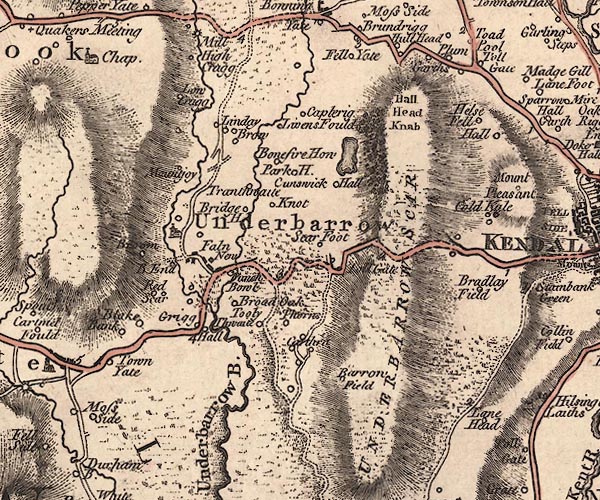 J5SD49SE.jpg "Helse Fell Hall" circle, labelled in italic lowercase text; settlement, farm, house, or hamlet? item:- National Library of Scotland : EME.s.47 Image © National Library of Scotland |
|
|
|
||
| evidence:- | database:- Listed Buildings 2010 placename:- Helsfell Farm |
|
| source data:- | courtesy of English Heritage "HELSFELL FARMHOUSE / / / STRICKLAND KETEL / SOUTH LAKELAND / CUMBRIA / II / 76412 / SD4980293911" |
|
|
|
||
| evidence:- | database:- Listed Buildings 2010 |
|
| source data:- | courtesy of English Heritage "BARN 200 METRES SOUTH EAST OF HELSFELL FARMHOUSE / / / STRICKLAND KETEL / SOUTH LAKELAND / CUMBRIA / II / 76413 / SD4999693828" |
|
|
|
||
 Lakes Guides menu.