 Old Cumbria Gazetteer
 |
 |
|
| chapel, Distington | ||
| civil parish:- | Distington (formerly Cumberland) | |
| county:- | Cumbria | |
| locality type:- | buildings | |
| locality type:- | chapel (ex) | |
| locality type:- | methodist chapel (ex) | |
| coordinates:- | NY00482265 | |
| 1Km square:- | NY0022 | |
| 10Km square:- | NY02 | |
| references:- | Listed Buildings 2010 |
|
|
|
||
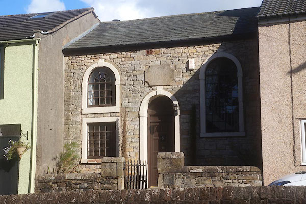 CFL57.jpg (taken 2.9.2016) 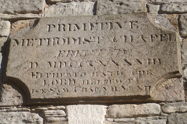 CFL58.jpg "PRIMITIVE / METHODIST CHAPEL / ERECTED / [A]D MDCCCXXXVIII / ..." (taken 2.9.2016) Plaque:- |
||
|
|
||
| evidence:- | old map:- OS County Series (Cmd 61 7) |
|
| source data:- | Maps, County Series maps of Great Britain, scales 6 and 25
inches to 1 mile, published by the Ordnance Survey, Southampton,
Hampshire, from about 1863 to 1948. "Methodist Chapel (Primitive)" |
|
|
|
||
| evidence:- | database:- Listed Buildings 2010 |
|
| source data:- | courtesy of English Heritage "METHODIST CHAPEL, AREA WALL AND CENTRAL GATE / / A595 / DISTINGTON / COPELAND / CUMBRIA / II / 76114 / NY0048622655" |
|
| source data:- | courtesy of English Heritage "Methodist Chapel, disused at time of survey (January 1984). Stone tablet over door inscribed and dated, with text, PRIMITIVE METHODIST CHAPEL ERECTED AD MDCCCXXXVIII. Snecked rubble. Graduated slate roof. Single tall storey, 3 bays; set back from adjoining houses. Symmetrical, with double panelled doors and boarded semicircular fanlight in stone surround; single semicircular headed window to either side, boarded over, in stone surround. Surrounds have projecting imposts and keystone. Area wall snecked rubble with semicircular copings, c6 ft high. Central gate has cast-iron spearhead standards." |
|
|
|
||
 Lakes Guides menu.