 Old Cumbria Gazetteer
 |
 |
|
| castle, Wreay | ||
| once | ||
| Petteril Wreay Castle | ||
| locality:- | Inglewood Forest | |
| locality:- | Wreay | |
| civil parish:- | St Cuthbert Without (formerly Cumberland) | |
| county:- | Cumbria | |
| locality type:- | castle (gone?) | |
| 1Km square:- | NY4348 | |
| 10Km square:- | NY44 | |
|
|
||
| evidence:- | old map:- Saxton 1579 placename:- Petterell Wrey |
|
| source data:- | Map, hand coloured engraving, Westmorlandiae et Cumberlandiae Comitatus ie Westmorland
and Cumberland, scale about 5 miles to 1 inch, by Christopher Saxton, London, engraved
by Augustinus Ryther, 1576, published 1579-1645.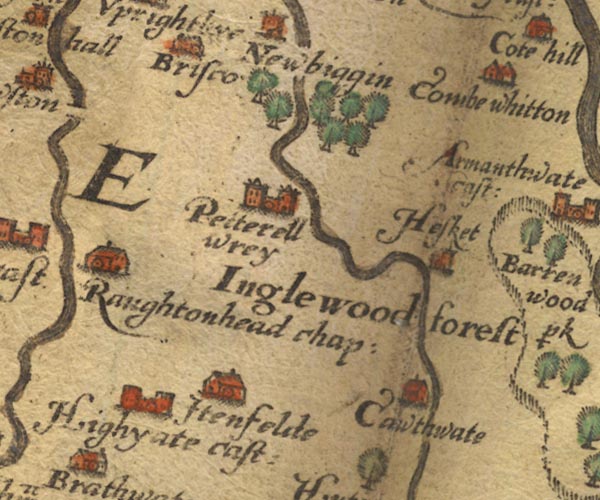 Sax9NY44.jpg Building with two towers, symbol for a castle. "Petterell wrey" Castle? item:- private collection : 2 Image © see bottom of page |
|
|
|
||
| evidence:- | probably old map:- Jenner 1643 placename:- Pettwray Castle |
|
| source data:- | Tables of distances with a maps, Westmerland, scale about 16
miles to 1 inch, and Cumberland, scale about 21 miles to 1 inch,
published by Thomas Jenner, London, 1643; published 1643-80. JEN4Sq.jpg "Pettwray ca" circle |
|
|
|
||
| evidence:- | probably old text:- Camden 1789 (Gough Additions) placename:- Castle Luen |
|
| source data:- | Book, Britannia, or A Chorographical Description of the Flourishing Kingdoms of England,
Scotland, and Ireland, by William Camden, 1586, translated from the 1607 Latin edition
by Richard Gough, published London, 1789. goto source goto sourcePage 189:- "..." ""Yn the forest of Ynglewood, vi myls from Caerluel, appere ruins of a castel, called Castle Luen."" |
|
|
|
||
Lakes Guides menu.