 Old Cumbria Gazetteer
 |
 |
|
| castle, Down Hall | ||
| Down Hall Castle | ||
| Downhall Castle | ||
| locality:- | Down Hall | |
| civil parish:- | Aikton (formerly Cumberland) | |
| county:- | Cumbria | |
| locality type:- | castle (site) | |
| coordinates:- | NY28265255 | |
| 1Km square:- | NY2852 | |
| 10Km square:- | NY25 | |
| references:- | Jackson 1990 |
|
|
|
||
| evidence:- | old map:- OS County Series (Cmd 22 15) placename:- Downhall |
|
| source data:- | Maps, County Series maps of Great Britain, scales 6 and 25
inches to 1 mile, published by the Ordnance Survey, Southampton,
Hampshire, from about 1863 to 1948. |
|
|
|
||
| evidence:- | site plan:- Curwen 1913 |
|
| source data:- | Site plan, lithograph, Plan of Moated Hall at Down Hall, Aikton, Cumberland, published
for the Cumberland and Westmorland Antiquarian and Archaeological Society by Titus
Wilson, Kendal, Westmorland, 1913.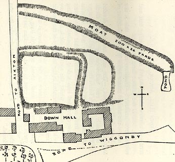 click to enlarge click to enlargeCW0110.jpg On p.43 of The Castles and Fortified Towers of Cumberland, Westmorland, and Lancashire North of the Sands, by John F Curwen. printed at bottom:- "PLAN OF MOATED GRANGE AT DOWN HALL, AIKTON." item:- Armitt Library : A782.10 Image © see bottom of page |
|
|
|
||
| notes:- |
earthworks and moat, site of a manor house |
|
| Perriam, D R &Robinson, J: 1998: Medieval Fortified Buildings of Cumbria: CWAAS::
ISBN 1 873124 23 6 |
||
|
|
||
| hearsay:- |
12th century castle attributed to of Hugh de Morville |
|
|
|
||
 Lakes Guides menu.