 Old Cumbria Gazetteer
 |
 |
|
| Broad Oak, Underbarrow | ||
| Broad Oak | ||
| civil parish:- | Underbarrow and Bradleyfield (formerly Westmorland) | |
| county:- | Cumbria | |
| locality type:- | buildings | |
| coordinates:- | SD46869177 | |
| 1Km square:- | SD4691 | |
| 10Km square:- | SD49 | |
| references:- | Listed Buildings 2010 |
|
|
|
||
| evidence:- | old map:- OS County Series (Wmd 38 6) placename:- Broadoak |
|
| source data:- | Maps, County Series maps of Great Britain, scales 6 and 25
inches to 1 mile, published by the Ordnance Survey, Southampton,
Hampshire, from about 1863 to 1948. |
|
|
|
||
| evidence:- | old map:- Jefferys 1770 (Wmd) placename:- Broad Oak |
|
| source data:- | Map, 4 sheets, The County of Westmoreland, scale 1 inch to 1
mile, surveyed 1768, and engraved and published by Thomas
Jefferys, London, 1770.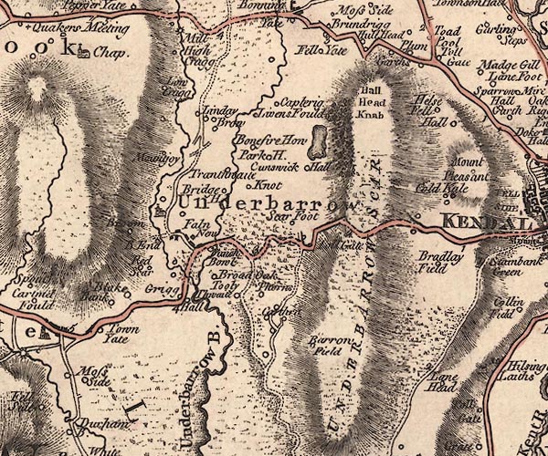 J5SD49SE.jpg "Broad Oak" circle, labelled in italic lowercase text; settlement, farm, house, or hamlet? item:- National Library of Scotland : EME.s.47 Image © National Library of Scotland |
|
|
|
||
| evidence:- | database:- Listed Buildings 2010 placename:- Broad Oak Farm item:- date stone (1565) |
|
| source data:- | courtesy of English Heritage "BROAD OAK FARMHOUSE AND ATTACHED OUTBUILDINGS / / / UNDERBARROW AND BRADLEYFIELD / SOUTH LAKELAND / CUMBRIA / II / 75301 / SD4686491776" |
|
|
|
||
| hearsay:- |
Over the front door is a date stone:- |
|
| "1565" |
||
| Palmer, J H & McIntire, W T (ed): 1945: Historic Farmhouses in and around Westmorland:
Westmorland Gazette (Kendal, Westmorland) |
||
|
|
||
 Lakes Guides menu.