 Old Cumbria Gazetteer
 |
 |
|
| Blaatwood, Scotland | ||
| gone | ||
| Blaatwood | ||
| country:- | Scotland | |
| locality type:- | building/s (site) | |
| coordinates:- | NY279660 (about) | |
| 1Km square:- | NY2766 | |
| 10Km square:- | NY26 | |
|
|
||
| evidence:- | old map:- OS County Series (Dmf 63) placename:- Blaatwood |
|
| source data:- | Maps, County Series maps of Great Britain, scales 6 and 25
inches to 1 mile, published by the Ordnance Survey, Southampton,
Hampshire, from about 1863 to 1948. "Blaatwood" |
|
|
|
||
| evidence:- | perhaps old map:- Burghley 1590 (facsimile) placename:- Blawit |
|
| source data:- | Facsimile map, A Platt of the Opposete Border of Scotland to ye West Marches of England,
parts of Cumberland and Scotland including the Debateable Land, from a manuscript
drawn for William Cecil, Lord Burghley, about 1590, published by R B Armstrong, 1897. courtesy of the National Library of Scotland 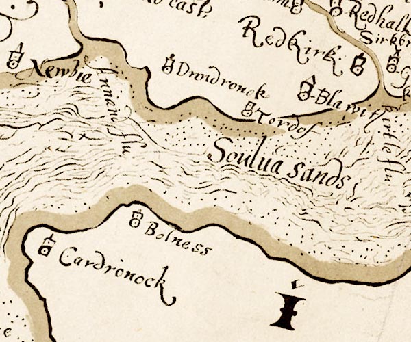 M048NY26.jpg "Blawit" circle, tower item:- National Library of Scotland : MS6113 f.267 Image © National Library of Scotland |
|
|
|
||
 Lakes Guides menu.