 Old Cumbria Gazetteer
 |
 |
|
| Badger Dub, Garsdale | ||
| Badger Dub | ||
| Badgerdub House | ||
| Street:- | Hawes Road | |
| civil parish:- | Garsdale (formerly Yorkshire) | |
| county:- | Cumbria | |
| locality type:- | buildings | |
| coordinates:- | SD72319062 | |
| 1Km square:- | SD7290 | |
| 10Km square:- | SD79 | |
| references:- | Listed Buildings 2010 |
|
|
|
||
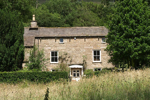 BWY90.jpg (taken 27.7.2012) |
||
|
|
||
| evidence:- | old map:- OS County Series (Yrk 64 6) placename:- Badger Dub |
|
| source data:- | Maps, County Series maps of Great Britain, scales 6 and 25
inches to 1 mile, published by the Ordnance Survey, Southampton,
Hampshire, from about 1863 to 1948. "Badger Dub" |
|
|
|
||
| evidence:- | database:- Listed Buildings 2010 placename:- Badger Dub |
|
| source data:- | courtesy of English Heritage "BADGER DUB AND STABLE OR SHIPPON ATTACHED TO SOUTH WEST / / HAWES ROAD / GARSDALE / SOUTH LAKELAND / CUMBRIA / II[star] / 484438 / SD7231290629" |
|
|
|
||
| evidence:- | database:- Listed Buildings 2010 |
|
| source data:- | courtesy of English Heritage "PRIVY APPROXIMATELY 5 METRES EAST OF BADGER DUB / / HAWES ROAD / GARSDALE / SOUTH LAKELAND / CUMBRIA / II / 484440 / SD7232690622" |
|
| source data:- | courtesy of English Heritage "Privy. Probably C18. Large roughly-coursed sandstone rubble, monopitched stone slate roof. Rectangular plan facing west. Built as bridge over fast-flowing beck. North side wall leaning at time of survey (October 1994). Forms group with Badger Dub (qv)." |
|
|
|
||
 Lakes Guides menu.