 Old Cumbria Gazetteer
 |
 |
|
| Wardhall Hall, Plumbland | ||
| Wardhall Hall | ||
| locality:- | Wardhall | |
| civil parish:- | Plumbland (formerly Cumberland) | |
| county:- | Cumbria | |
| locality type:- | buildings | |
| coordinates:- | NY13073841 | |
| 1Km square:- | NY1338 | |
| 10Km square:- | NY13 | |
|
|
||
| evidence:- | old map:- OS County Series (Cmd 35 16) placename:- Warthole Hall placename:- Old Hall |
|
| source data:- | Maps, County Series maps of Great Britain, scales 6 and 25
inches to 1 mile, published by the Ordnance Survey, Southampton,
Hampshire, from about 1863 to 1948. "Warthole Hall / Old Hall (Site of)" |
|
|
|
||
| evidence:- | old map:- Donald 1774 (Cmd) placename:- Warthall Hall |
|
| source data:- | Map, hand coloured engraving, 3x2 sheets, The County of Cumberland, scale about 1
inch to 1 mile, by Thomas Donald, engraved and published by Joseph Hodskinson, 29
Arundel Street, Strand, London, 1774.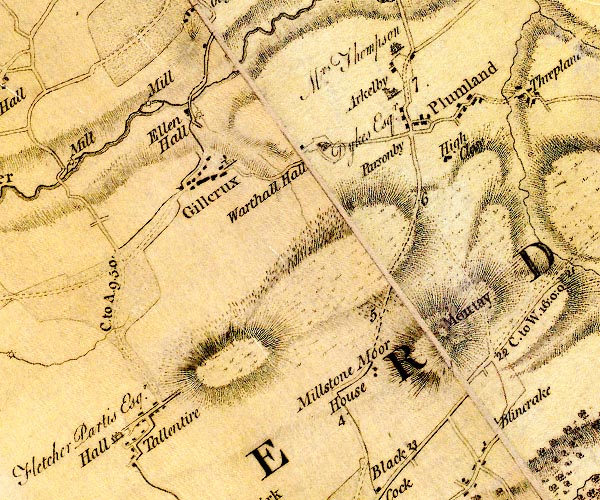 D4NY13NW.jpg "Warthall Hall / Dykes Esqr." house item:- Carlisle Library : Map 2 Image © Carlisle Library |
|
|
|
||
| notes:- |
Supposed site of a castle, later a house which is now demolished |
|
| Perriam, D R &Robinson, J: 1998: Medieval Fortified Buildings of Cumbria: CWAAS::
ISBN 1 873124 23 6 |
||
|
|
||
 Lakes Guides menu.