 Old Cumbria Gazetteer
 |
 |
|
| Low Force, Alston Moor | ||
| Low Force | ||
| site name:- | Nent, River | |
| locality:- | Alston | |
| civil parish:- | Alston Moor (formerly Cumberland) | |
| county:- | Cumbria | |
| locality type:- | waterfall | |
| coordinates:- | NY72014673 | |
| 1Km square:- | NY7246 | |
| 10Km square:- | NY74 | |
|
|
||
| evidence:- | old map:- OS County Series (Cmd 34 9) placename:- Low Force placename:- Force, Low |
|
| source data:- | Maps, County Series maps of Great Britain, scales 6 and 25
inches to 1 mile, published by the Ordnance Survey, Southampton,
Hampshire, from about 1863 to 1948. |
|
|
|
||
| evidence:- | old map:- OS County Series (Cmd 34) placename:- Low Force |
|
| source data:- | Maps, County Series maps of Great Britain, scales 6 and 25
inches to 1 mile, published by the Ordnance Survey, Southampton,
Hampshire, from about 1863 to 1948. "Low Force (Waterfall)" |
|
|
|
||
| evidence:- | old print:- Wallace 1861 placename:- Nent Force |
|
| source data:- | Print, lithograph, Nent Force, drawn by William Wallace, published by Edward Stanford,
6 Charing Cross, London, 1861.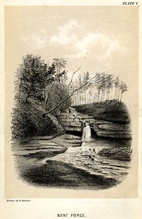 click to enlarge click to enlargeWC0105.jpg Frontispiece to The Laws which Regulate the Deposit of Lead Ore in Veins; plate 5. printed at bottom left, centre:- "Drawn by W. Wallace. / NENT FORCE." item:- private collection : 159.2 Image © see bottom of page |
|
|
|
||
 Lakes Guides menu.