 Old Cumbria Gazetteer
 |
 |
|
| Kirkby Slate Quarries, Kirkby Ireleth | ||
| Kirkby Slate Quarries | ||
| site name:- | Furness Railway | |
| civil parish:- | Kirkby Ireleth (formerly Lancashire) | |
| county:- | Cumbria | |
| locality type:- | slate quarry | |
| locality type:- | quarry | |
| coordinates:- | SD24448366 (etc etc) | |
| 1Km square:- | SD2483 | |
| 10Km square:- | SD28 | |
|
|
||
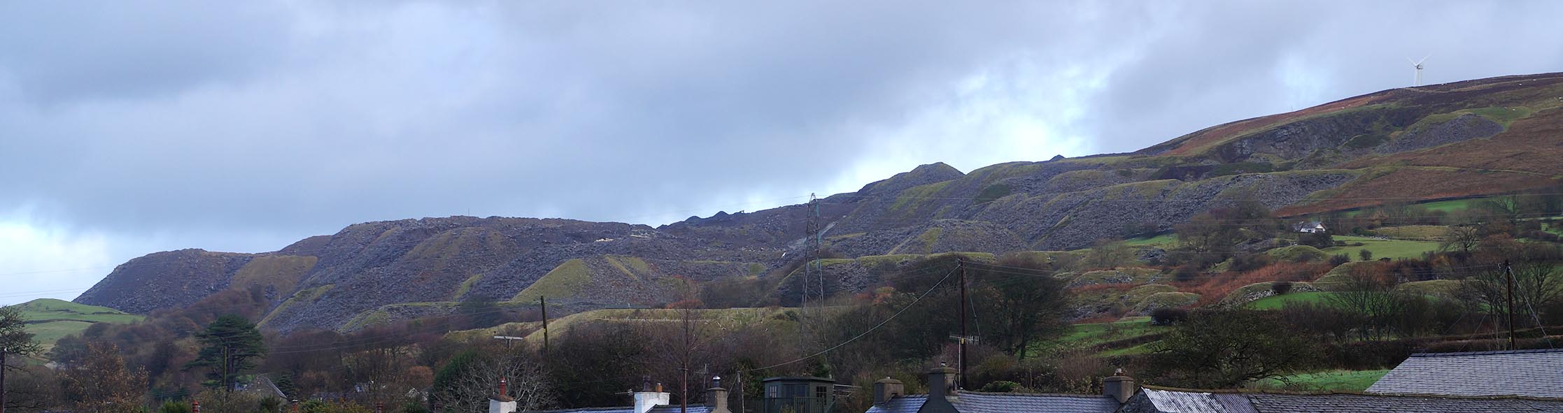 Click to enlarge CEJ44.jpg (taken 20.11.2015) |
||
|
|
||
| evidence:- | old map:- OS County Series (Lan 11 5) placename:- Kirkby Slate Quarries |
|
| source data:- | Maps, County Series maps of Great Britain, scales 6 and 25
inches to 1 mile, published by the Ordnance Survey, Southampton,
Hampshire, from about 1863 to 1948. OS County Series (Lan 11 6) |
|
|
|
||
| evidence:- | old map:- OS County Series (Lan 11 5) placename:- Burlington Slate Works item:- slate depot; weighing machine |
|
| source data:- | Maps, County Series maps of Great Britain, scales 6 and 25
inches to 1 mile, published by the Ordnance Survey, Southampton,
Hampshire, from about 1863 to 1948.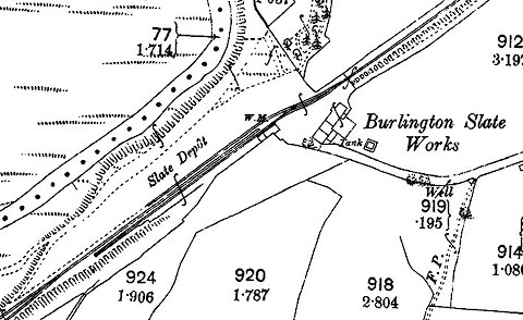 click to enlarge click to enlargeCSRY0124.jpg "Slate Depot / W.M. / Burlington Slate Works" |
|
|
|
||
| evidence:- | old map:- OS County Series (Lan 11) placename:- Kirkby Slate Quarries placename:- Hospital Quarry item:- slate |
|
| source data:- | Maps, County Series maps of Great Britain, scales 6 and 25
inches to 1 mile, published by the Ordnance Survey, Southampton,
Hampshire, from about 1863 to 1948. "Kirkby Slate Quarries / Hospital Quarry (Slate)" |
|
|
|
||
| evidence:- | old map:- OS County Series (Lan 11) placename:- Kirkby Slate Quarries placename:- Hunter's Quarry item:- slate |
|
| source data:- | Maps, County Series maps of Great Britain, scales 6 and 25
inches to 1 mile, published by the Ordnance Survey, Southampton,
Hampshire, from about 1863 to 1948. "Kirkby Slate Quarries / Hunter's Quarry (Slate)" |
|
|
|
||
| evidence:- | old map:- OS County Series (Lan 11) placename:- Kirkby Slate Quarries placename:- Lord Quarry, The item:- slate |
|
| source data:- | Maps, County Series maps of Great Britain, scales 6 and 25
inches to 1 mile, published by the Ordnance Survey, Southampton,
Hampshire, from about 1863 to 1948. "Kirkby Slate Quarries / The Lord Quarry (Slate)" |
|
|
|
||
| evidence:- | old map:- OS County Series (Lan 11) placename:- Kirkby Slate Quarries placename:- Town Quarry, The item:- slate |
|
| source data:- | Maps, County Series maps of Great Britain, scales 6 and 25
inches to 1 mile, published by the Ordnance Survey, Southampton,
Hampshire, from about 1863 to 1948. "Kirkby Slate Quarries / The Town Quarry (Slate)" |
|
|
|
||
| evidence:- | old map:- OS County Series (Lan 11) placename:- Kirkby Slate Quarries placename:- Smithy Hill Quarry item:- slate |
|
| source data:- | Maps, County Series maps of Great Britain, scales 6 and 25
inches to 1 mile, published by the Ordnance Survey, Southampton,
Hampshire, from about 1863 to 1948. "Kirkby Slate Quarries / Smithy Hill Quarry (Slate)" |
|
|
|
||
| evidence:- | old map:- OS County Series (Lan 11) placename:- Kirkby Slate Quarries placename:- High Quarry, The item:- slate |
|
| source data:- | Maps, County Series maps of Great Britain, scales 6 and 25
inches to 1 mile, published by the Ordnance Survey, Southampton,
Hampshire, from about 1863 to 1948. "Kirkby Slate Quarries / The High Quarry (Slate)" |
|
|
|
||
| evidence:- | old map:- OS County Series (Lan 11) placename:- Old Crow Brow Quarry item:- slate |
|
| source data:- | Maps, County Series maps of Great Britain, scales 6 and 25
inches to 1 mile, published by the Ordnance Survey, Southampton,
Hampshire, from about 1863 to 1948. "Old Crow Brow Quarry (Slate)" |
|
|
|
||
| evidence:- | old map:- OS County Series (Lan 11) placename:- New Crow Brow Quarry item:- slate |
|
| source data:- | Maps, County Series maps of Great Britain, scales 6 and 25
inches to 1 mile, published by the Ordnance Survey, Southampton,
Hampshire, from about 1863 to 1948. "New Crow Brow Quarry (Slate)" |
|
|
|
||
| evidence:- | old map:- OS County Series (Lan 11) placename:- Winnow End Quarry item:- slate |
|
| source data:- | Maps, County Series maps of Great Britain, scales 6 and 25
inches to 1 mile, published by the Ordnance Survey, Southampton,
Hampshire, from about 1863 to 1948. "Winnow End Quarry (Slate)" |
|
|
|
||
| see:- |  Kirkby Slate Quarries tramroad Kirkby Slate Quarries tramroad |
|
|
|
||
Lakes Guides menu.