 Old Cumbria Gazetteer
 |
 |
|
| Helsfell Hall, Strickland Ketel | ||
| Helsfell Hall | ||
| civil parish:- | Strickland Ketel (formerly Westmorland) | |
| county:- | Cumbria | |
| locality type:- | buildings | |
| coordinates:- | SD49999383 | |
| 1Km square:- | SD4993 | |
| 10Km square:- | SD49 | |
| SummaryText:- | This hall is a listed building; the Helsfell Hall on present maps is an newer building. | |
|
|
||
| evidence:- | old map:- OS County Series (Wmd 38 3) placename:- Helsfell Hall |
|
| source data:- | Maps, County Series maps of Great Britain, scales 6 and 25
inches to 1 mile, published by the Ordnance Survey, Southampton,
Hampshire, from about 1863 to 1948. "Helsfell Hall" |
|
|
|
||
| evidence:- | old map:- Jefferys 1770 (Wmd) placename:- Helse Fell Hall |
|
| source data:- | Map, 4 sheets, The County of Westmoreland, scale 1 inch to 1
mile, surveyed 1768, and engraved and published by Thomas
Jefferys, London, 1770.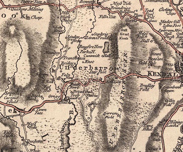 J5SD49SE.jpg "Helse Fell Hall" circle, labelled in italic lowercase text; settlement, farm, house, or hamlet? item:- National Library of Scotland : EME.s.47 Image © National Library of Scotland |
|
|
|
||
| evidence:- | old photograph:- Bell 1880s-1940s placename:- Helsfell Hall |
|
| source data:- | Photograph, Helsfell Hall, Strickland Ketel, Westmorland, by Herbert Bell, photographer,
Ambleside, Westmorland, 1895.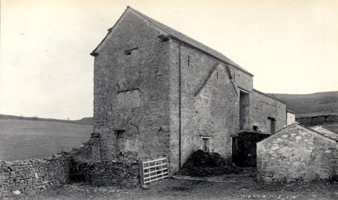 click to enlarge click to enlargeHB0155.jpg Vol.2 no.155 in an album, Examples of Early Domestic and Military Architecture in Westmorland, assembled 1910. ms at bottom:- "155. Helsfell Hall. Kendal. K." item:- Armitt Library : 1958.3166.49 Image © see bottom of page |
|
|
|
||
| notes:- |
hall |
|
| Perriam, D R &Robinson, J: 1998: Medieval Fortified Buildings of Cumbria: CWAAS::
ISBN 1 873124 23 6; illustration |
||
|
|
||
 Lakes Guides menu.