 Old Cumbria Gazetteer
 |
 |
|
| Crofton Station, Westward | ||
| Crofton Station | ||
| site name:- | Maryport and Carlisle Railway | |
| locality:- | Crofton | |
| civil parish:- | Westward (formerly Cumberland) | |
| county:- | Cumbria | |
| locality type:- | railway station (gone) | |
| coordinates:- | NY30814922 | |
| 1Km square:- | NY3049 | |
| 10Km square:- | NY34 | |
| references:- | OS County Series |
|
|
|
||
| evidence:- | old map:- OS County Series (Cmd 29 8) placename:- Crofton Station item:- railway milepost; railway bridge |
|
| source data:- | Maps, County Series maps of Great Britain, scales 6 and 25
inches to 1 mile, published by the Ordnance Survey, Southampton,
Hampshire, from about 1863 to 1948.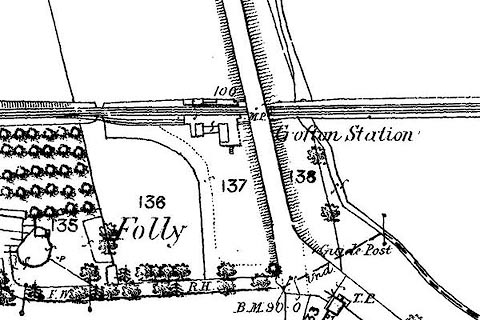 click to enlarge click to enlargeCSRY0044.jpg "Crofton Station / M.P." |
|
|
|
||
| hearsay:- |
Originally opened as a private station for the convenience of a local landowner, who
could stop trains on demand. |
|
|
|
||
 Lakes Guides menu.