 Old Cumbria Gazetteer
 |
 |
|
| Cowgill Bridge, Dent | ||
| Cowgill Bridge | ||
| site name:- | Cowgill Beck | |
| locality:- | Cowgill | |
| locality:- | Dentdale | |
| civil parish:- | Dent (formerly Yorkshire) | |
| county:- | Cumbria | |
| locality type:- | bridge | |
| coordinates:- | SD75628693 | |
| 1Km square:- | SD7586 | |
| 10Km square:- | SD78 | |
|
|
||
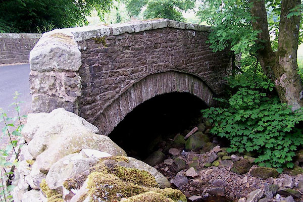 BMG65.jpg (taken 16.6.2006) 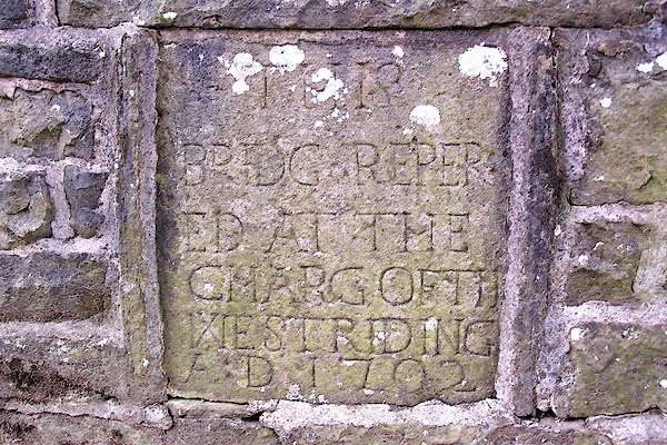 BMG66.jpg Inscribed stone:- "THIS BRIDGE REPERED AT THE CHARG OF TH WEST RIDING A.D.1702" (taken 16.6.2006) |
||
|
|
||
| evidence:- | old map:- OS County Series (Yrk 64 15) placename:- Cowgill Bridge |
|
| source data:- | Maps, County Series maps of Great Britain, scales 6 and 25
inches to 1 mile, published by the Ordnance Survey, Southampton,
Hampshire, from about 1863 to 1948. "Cowgill Bridge" |
|
|
|
||
| evidence:- | database:- Listed Buildings 2010 placename:- Cowgill Bridge |
|
| source data:- | courtesy of English Heritage "COWGILL BRIDGE / / / DENT / SOUTH LAKELAND / CUMBRIA / II / 484271 / SD7562986936" |
|
| source data:- | courtesy of English Heritage "Public road bridge over River Dee. Dated 1702 on north parapet. Coursed sandstone rubble with low-pitched parapet copings. Low segmental arch with rubble voussoirs and arch-bands; parapets splayed outwards at west end. The north parapet incorporates a square datestone inscribed: "THIS / BRIDG REPER / ED. AT THE / CHARGE OF THE / WEST RIDING / A.D.1702"." |
|
|
|
||
 Lakes Guides menu.