 Old Cumbria Gazetteer
 |
 |
|
| Burton Hall, Warcop | ||
| Burton Hall | ||
| locality:- | Burton (?) | |
| civil parish:- | Warcop (formerly Westmorland) | |
| county:- | Cumbria | |
| locality type:- | building/s (gone?) | |
| locality type:- | fish pond (extant) | |
| coordinates:- | NY74521851 (?) | |
| 1Km square:- | NY7418 | |
| 10Km square:- | NY71 | |
| references:- | OS County Series |
|
|
|
||
| evidence:- | old map:- OS County Series (Wmd 16 5) placename:- Burton Hall |
|
| source data:- | Maps, County Series maps of Great Britain, scales 6 and 25
inches to 1 mile, published by the Ordnance Survey, Southampton,
Hampshire, from about 1863 to 1948. "Burton Hall" and nearby the fish ponds |
|
|
|
||
| evidence:- | hearth tax returns:- Hearth Tax 1675 placename:- Burton Hall |
|
| source data:- | Records, hearth tax survey returns, Westmorland, 1674/75. "Burton Hall" in "Burton" |
|
|
|
||
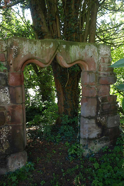 BVA87.jpg 14th or 15th century door arch from the hall, now at St Columba, Warcop. (taken 24.7.2011) |
||
|
|
||
| notes:- |
site of 14th century hall - demolished, moat, fish ponds |
|
| Perriam, D R &Robinson, J: 1998: Medieval Fortified Buildings of Cumbria: CWAAS::
ISBN 1 873124 23 6 |
||
|
|
||
 Lakes Guides menu.