 Old Cumbria Gazetteer
 |
 |
|
| included in:- |
 limekilns, Coniston Limestone Series limekilns, Coniston Limestone Series |
|
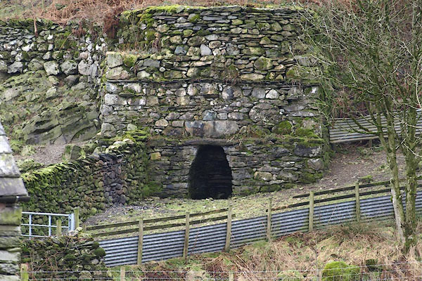
| limekiln, Kentmere | ||
| locality:- | Kentmere | |
| civil parish:- | Kentmere (formerly Westmorland) | |
| county:- | Cumbria | |
| locality type:- | limekiln | |
| locality type:- | Coniston limestone series | |
| locality type:- | kiln | |
| locality type:- | geological site | |
| coordinates:- | NY45040432 | |
| 1Km square:- | NY4504 | |
| 10Km square:- | NY40 | |
| stratigraphy:- | Coniston Limestone Series | |
| references:- | OS County Series |
|
|
|
||
 BSB67.jpg (taken 3.2.2010) |
||
|
|
||
| evidence:- | old map:- OS County Series (Wmd 27 9) |
|
| source data:- | Maps, County Series maps of Great Britain, scales 6 and 25
inches to 1 mile, published by the Ordnance Survey, Southampton,
Hampshire, from about 1863 to 1948. "Limekiln" |
|
|
|
||
| evidence:- | database:- Listed Buildings 2010 |
|
| source data:- | courtesy of English Heritage "LIMEKILN TO NORTH WEST OF KENTMERE HALL / / / KENTMERE / SOUTH LAKELAND / CUMBRIA / II / 76480 / NY4504204322" |
|
| source data:- | courtesy of English Heritage "Limekiln, possibly C18. Roughly coursed rubble. Square in plan with arched opening. Chimney blocked but appears to be octagonal. Flat top. Built into side of hill: forms landscape feature." |
|
|
|
||
Lakes Guides menu.