 Old Cumbria Gazetteer
 |
 |
|
| milestone, Broughton Moor | ||
| site name:- | road, Cockermouth to Maryport | |
| locality:- | Linefoot | |
| civil parish:- | Broughton Moor (formerly Cumberland) | |
| county:- | Cumbria | |
| locality type:- | milestone | |
| coordinates:- | NY07873418 | |
| 1Km square:- | NY0734 | |
| 10Km square:- | NY03 | |
|
|
||
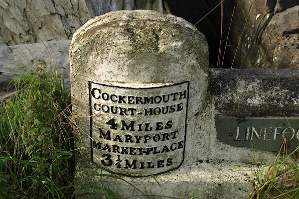 BRI53.jpg Cast iron plate on a stone, at the entrance to Linefoot farm:- "COCKERMOUTH / COURT-HOUSE / 4 MILES / MARYPORT / MARKET-PLACE / 3¼MILES" (taken 2.9.2009) |
||
|
|
||
| evidence:- | old map:- OS County Series (Cmd 45 10) |
|
| source data:- | Maps, County Series maps of Great Britain, scales 6 and 25
inches to 1 mile, published by the Ordnance Survey, Southampton,
Hampshire, from about 1863 to 1948. "MS Cockermouth 4 Maryport 3 1/2" |
|
|
|
||
| evidence:- | database:- Listed Buildings 2010 |
|
| source data:- | courtesy of English Heritage "MILESTONE AT ENTRANCE TO LINEFOOT FARM / / / BROUGHTON MOOR / ALLERDALE / CUMBRIA / II / 72225 / NY0789734176" |
|
| source data:- | courtesy of English Heritage "Milestone. Late C18 or early C19. Whitewashed red sandstone. Round-topped stone with cast iron plate to front inscribed COCKERMOUTH COURT-HOUSE 4 MILES, MARYPORT MARKET-PLACE 31/4 MILES. Lettering picked out in black. OS bench mark on top of stone." |
|
|
|
||
| hearsay:- |
The milestone, broken off, is said to have been rescued and cemented here, out of
position, by the farmer. |
|
|
|
||
 Lakes Guides menu.