 Old Cumbria Gazetteer
 |
 |
|
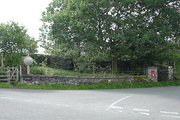
| pinfold, Outgate | ||
| locality:- | Outgate | |
| civil parish:- | Hawkshead (formerly Lancashire) | |
| county:- | Cumbria | |
| locality type:- | pinfold | |
| coordinates:- | SD35499981 | |
| 1Km square:- | SD3599 | |
| 10Km square:- | SD39 | |
|
|
||
 BTI41.jpg (taken 13.8.2010) |
||
|
|
||
| evidence:- | old map:- OS County Series (Lan 2 14) |
|
| source data:- | Maps, County Series maps of Great Britain, scales 6 and 25
inches to 1 mile, published by the Ordnance Survey, Southampton,
Hampshire, from about 1863 to 1948. "Pound" |
|
|
|
||
| evidence:- | database:- Listed Buildings 2010 |
|
| source data:- | courtesy of English Heritage "FORMER VILLAGE POUND / / B 5286 / HAWKSHEAD / SOUTH LAKELAND / CUMBRIA / II / 76831 / SD3550099800" |
|
| source data:- | courtesy of English Heritage "Pound. Possibly C18 or earlier in origin. Stone rubble. Roughly rectangular enclosure, wall to street is approx 13.5m long, low, with concrete coping and iron rails; post box in pier next to small gate. South wall is similar, north and west walls higher." |
|
|
|
||
 Lakes Guides menu.