 Old Cumbria Gazetteer
 |
 |
|
| boundary stone, Casterton | ||
| civil parish:- | Casterton (formerly Westmorland) | |
| county:- | Cumbria | |
| locality type:- | boundary stone | |
| locality type:- | county boundary mark | |
| coordinates:- | SD61867791 | |
| 1Km square:- | SD6177 | |
| 10Km square:- | SD67 | |
| county:- | Lancashire | |
| current boundary | ||
| locality:- | Cumbria boundary | |
| old boundary | ||
| locality:- | Westmorland boundary | |
|
|
||
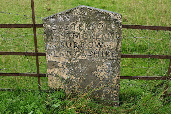 BRH17.jpg Inscribed stone:- "CASTERTON / WESTMORLAND / BURROW / LANCASHIRE" (taken 13.8.2009) |
||
|
|
||
| evidence:- | database:- Listed Buildings 2010 |
|
| source data:- | courtesy of English Heritage "BOUNDARY STONE APPROXIMATELY 90M SOUTH OF A65 JUNCTION / / A683 / CASTERTON / SOUTH LAKELAND / CUMBRIA / II / 75613 / SD6185077921" |
|
| source data:- | courtesy of English Heritage "COUNTY BOUNDARY STONE / / A683 / BURROW WITH BURROW / LANCASTER / LANCASHIRE / II / 182349 / SD6186877909" |
|
| source data:- | courtesy of English Heritage "Boundary stone, probably early C19th. Comprises an upright sandstone flag with a pitched top. Face inscribed: 'CASTERTON WESTMORLAND. BURROW LANCASHIRE.' Part of this boundary stone is in Casterton C.P., in the County of Cumbria (q.v.)" |
|
| source data:- | courtesy of English Heritage "Boundary stone. Probably early C19. Dressed stone with ashlar panel. Flat triangular-headed stone with inscription: "CASTERTON/WESTMORLAND/BURROW/ LANCASHIRE", and 2 arrows. Connected with the Lancaster-Kirkby Lonsdale turnpike road." |
|
|
|
||
 Lakes Guides menu.