 Old Cumbria Gazetteer
 |
 |
|
| Wardrew, Northumberland | ||
| Wardrew | ||
| county:- | Northumberland | |
| locality type:- | buildings | |
| coordinates:- | NY638679 | |
| 1Km square:- | NY6367 | |
| 10Km square:- | NY66 | |
|
|
||
| evidence:- | old map:- Donald 1774 (Cmd) placename:- Wardrew |
|
| source data:- | Map, hand coloured engraving, 3x2 sheets, The County of Cumberland, scale about 1
inch to 1 mile, by Thomas Donald, engraved and published by Joseph Hodskinson, 29
Arundel Street, Strand, London, 1774.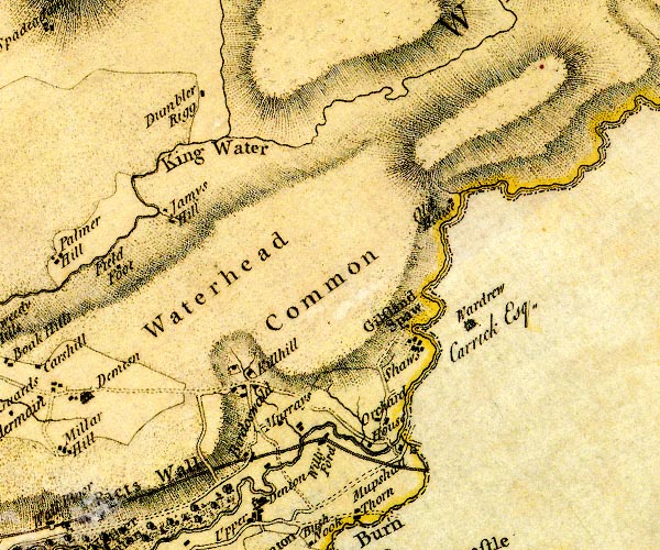 D4NY66NW.jpg "Wardrew / Carrick Esq." house item:- Carlisle Library : Map 2 Image © Carlisle Library |
|
|
|
||
| evidence:- | descriptive text:- OS County Series placename:- Wardrew |
|
| source data:- | Maps, County Series maps of Great Britain, scales 6 and 25
inches to 1 mile, published by the Ordnance Survey, Southampton,
Hampshire, from about 1863 to 1948. |
|
|
|
||
| evidence:- | descriptive text:- Ford 1839 (3rd edn 1843) placename:- Wardrew House |
|
| source data:- | Guide book, A Description of Scenery in the Lake District, by
Rev William Ford, published by Charles Thurnam, Carlisle, by W
Edwards, 12 Ave Maria Lane, Charles Tilt, Fleet Street, William
Smith, 113 Fleet Street, London, by Currie and Bowman,
Newcastle, by Bancks and Co, Manchester, by Oliver and Boyd,
Edinburgh, and by Sinclair, Dumfries, 1839. goto source goto sourcePage 116:- "..." "[Gilsland Spa] was originally known by the name of the Holy Well, also by that of Wardrew Spa, the latter name being taken from the tenement and farm on the Northumberland side of the water, and which appears to have been, at one time, the only original place of entertainment. The present mansion was erected in 1752, and is a large and elegantly-" goto sourcePage 117:- "[elegantly-]finished place, though now in a state of great delapidation." |
|
|
|
||
Lakes Guides menu.