 Old Cumbria Gazetteer
 |
 |
|
| Southerness Lighthouse, Scotland | ||
| Southerness Lighthouse | ||
| locality:- | Southerness Point | |
| country:- | Scotland | |
| locality type:- | lighthouse (disused) | |
| 1Km square:- | NX9754 | |
| 10Km square:- | NX95 | |
|
|
||
| evidence:- | old map:- Walker 1842 placename:- Satterness |
|
| source data:- | Chart, Position of all the Lighthouses in the British Isles,
scale about 38 nautical miles to 1 inch, published by J and A
Walker, 72 South Castle Street, Liverpool, Lancashire, 1842. marked as a coast light "Satterness - Steady" |
|
|
|
||
| evidence:- | old map:- Geddes 1848 placename:- Southerness Light House |
|
| source data:- | Chart, uncoloured engraving, Sketch of the English Channel from
the Bar up to Port Carlisle, in the Solway Firth, scale about 2
ins to 1 mile, by W Geddes, 1848.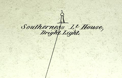 click to enlarge click to enlargeGD01P2.jpg "Southerness Lt. House / Bright Light" item:- Carlisle Library : Map 91 Image © Carlisle Library |
|
|
|
||
| evidence:- | old text:- |
|
| source data:- | : 1974: West Coasts of England and Wales Pilot "... Southerness Point ... A disused lighthouse stands close off the point. ..." |
|
|
|
||
| evidence:- | old print:- |
|
| source data:- | Print, hand coloured engraving, Entrance to Silloth Bay and Dock, Cumberland, published
by Hudson Scott, litho printer, Carlisle, Cumbria, 1870.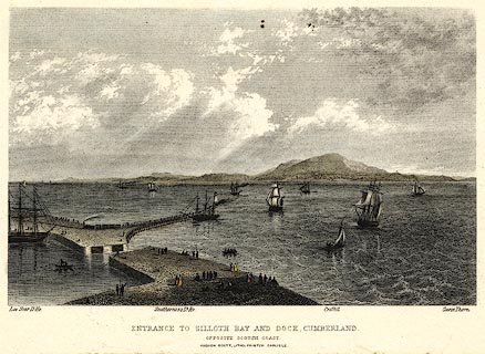 click to enlarge click to enlargePR0369.jpg There is shipping in the offing and at the dock, a train leaving the quay; some scottish coastal features are labelled - Lee Scar lighthouse, Southerness lighthouse, Criffel and Carse Thorn. printed at bottom:- "ENTRANCE TO SILLOTH BAY AND DOCK, CUMBERLAND. / OPPOSITE THE SCOTCH COAST / HUDSON SCOTT, LITHO PRINTER CARLISLE." item:- Dove Cottage : 2008.107.369 Image © see bottom of page |
|
|
|
||
 Lakes Guides menu.