 Old Cumbria Gazetteer
 |
 |
|
| Solway Light Vessel, Solway Firth | ||
| Solway Light Vessel | ||
| locality:- | Solway Firth | |
| country:- | England (?) | |
| locality type:- | lightship | |
| 1Km square:- | NY0344 (approx) | |
| 10Km square:- | NY04 | |
| references:- | Hydrographic Office 1850s-90s |
|
|
|
||
| evidence:- | old map:- Geddes 1848 placename:- Solway Light Ship |
|
| source data:- | Chart, uncoloured engraving, Sketch of the English Channel from
the Bar up to Port Carlisle, in the Solway Firth, scale about 2
ins to 1 mile, by W Geddes, 1848.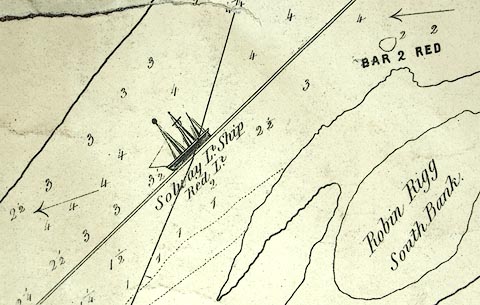 click to enlarge click to enlargeGD01P.jpg "Solway Lt. Ship / Red Light" item:- Carlisle Library : Map 91 Image © Carlisle Library |
|
|
|
||
| evidence:- | old map:- Hydrographic Office 1850s onwards placename:- Solway Light Vessel |
|
| source data:- | Chart, uncoloured engraving, England West Coast sheet XII, Firth
of Solway, scale about 1 inch to 1 mile, surveyed by C G
Robinson, 1837, engraved by J and C Walker, published by the
Hydrographic Office, The Admiralty, London, 1841-58. Admiralty chart 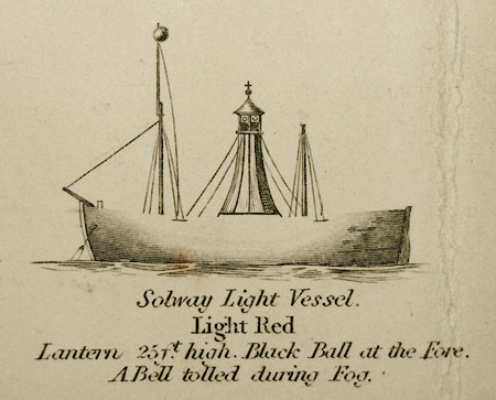 HY02P1.jpg "Solway Light Vessel. / Light Red / Lantern 25ft. high. Black Ball at the Fore. / A Bell tolled during Fog." 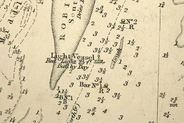 HY02P2.jpg "Light Vessel / Red Light 25 ft / Ball by Day" item:- Carlisle Library : Map 94 Images © Carlisle Library |
|
|
|
||
 Lakes Guides menu.