 Old Cumbria Gazetteer
 |
 |
|
| milestone, Staveley-in-Cartmel | ||
| site name:- | road, Kendal to Ulverston (?) | |
| civil parish:- | Staveley-in-Cartmel (formerly Lancashire) | |
| county:- | Cumbria | |
| locality type:- | milestone | |
| coordinates:- | SD37358625 | |
| 1Km square:- | SD3786 | |
| 10Km square:- | SD38 | |
|
|
||
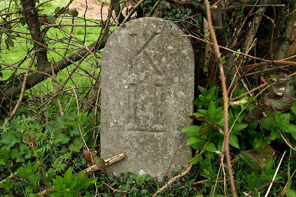 BPC51.jpg Inscribed stone:- "K / 11" (taken 26.4.2008) |
||
|
|
||
| evidence:- | old map:- OS County Series (Lan 8) |
|
| source data:- | Maps, County Series maps of Great Britain, scales 6 and 25
inches to 1 mile, published by the Ordnance Survey, Southampton,
Hampshire, from about 1863 to 1948. "M.S. KENDAL 11" |
|
|
|
||
| evidence:- | database:- Listed Buildings 2010 |
|
| source data:- | courtesy of English Heritage "MILESTONE OPPOSITE END OF LANE TO STAVELEY / / A592 / STAVELEY IN CARTMEL / SOUTH LAKELAND / CUMBRIA / II / 421915 / SD3736086253" |
|
| source data:- | courtesy of English Heritage "Milestone. Late C18 or early C19. For Kirkby Kendal to Kirkby Ireleth Turnpike Trust. Stone. Round-headed post inscribed: "K/11" (miles to Kendal)." |
|
|
|
||
 Lakes Guides menu.