 Old Cumbria Gazetteer
 |
 |
|
| Kids Howe, Fawcett Forest | ||
| Kids Howe | ||
| civil parish:- | Fawcett Forest (formerly Westmorland) | |
| county:- | Cumbria | |
| locality type:- | hill | |
| coordinates:- | NY54660202 (etc) | |
| 1Km square:- | NY5402 | |
| 10Km square:- | NY50 | |
|
|
||
| evidence:- | old map:- OS County Series (Wmd 28 13) placename:- Kids Howe |
|
| source data:- | Maps, County Series maps of Great Britain, scales 6 and 25
inches to 1 mile, published by the Ordnance Survey, Southampton,
Hampshire, from about 1863 to 1948. |
|
|
|
||
| evidence:- | hearth tax returns:- Hearth Tax 1675 placename:- Kits howe in the Forrest |
|
| source data:- | Records, hearth tax survey returns, Westmorland, 1674/75. "Kits howe in the Forrest" in "Fawcett Forrest" |
|
|
|
||
| evidence:- | probably old map:- Hall 1820 (Wmd) placename:- Kitts How |
|
| source data:- | Map, hand coloured engraving, Westmoreland ie Westmorland, scale
about 14.5 miles to 1 inch, by Sidney Hall, London, 1820,
published by Samuel Leigh, 18 Strand, London, 1820-31. click to enlarge click to enlargeHA18.jpg "Kitts How" circle, italic lowercase text; settlement item:- Armitt Library : 2008.14.58 Image © see bottom of page |
|
|
|
||
| evidence:- | old map:- Ford 1839 map placename:- Kitts How |
|
| source data:- | Map, uncoloured engraving, Map of the Lake District of
Cumberland, Westmoreland and Lancashire, scale about 3.5 miles
to 1 inch, published by Charles Thurnam, Carlisle, and by R
Groombridge, 5 Paternoster Row, London, 3rd edn 1843.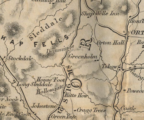 FD02NY50.jpg "Kitts How" item:- JandMN : 100.1 Image © see bottom of page |
|
|
|
||
 Lakes Guides menu.