 Old Cumbria Gazetteer
 |
 |
|
| Wythburn Head, Wythburn | ||
| Wythburn Head | ||
| locality:- | Wyth Burn | |
| civil parish:- | St John's Castlerigg and Wythburn (formerly Cumberland) | |
| county:- | Cumbria | |
| locality type:- | locality | |
| coordinates:- | NY29661116 (etc) | |
| 1Km square:- | NY2911 | |
| 10Km square:- | NY21 | |
|
|
||
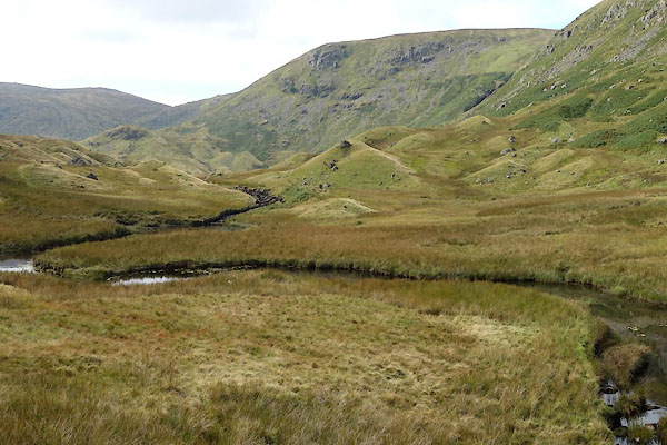 CBP68.jpg (taken 8.9.2014) 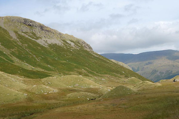 CBP69.jpg (taken 8.9.2014) |
||
|
|
||
| evidence:- | outline view:- Otley 1823 (5th edn 1834) |
|
| source data:- | Print, woodcut outline view, The Mountains of Grasmere and
Rydal, by Jonathan Otley, Keswick, Cumberland, 1830.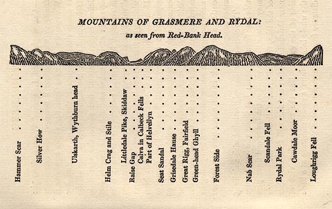 click to enlarge click to enlargeOT2E03.jpg Printed on p.15 of A Concise Description of the English Lakes, by Jonathan Otley, 5th edition, 1834. "MOUNTAINS OF GRASMERE AND RYDAL: as seen from Red-Bank Head." "Hammer Scar / Silver How / Ullskarth, Wythburn head / Helm Crag and Stile / Littledale Pike, Skiddaw / Raise Gap / Calva in Caldbeck Fells / Part of Helvellyn / Seat Sandal / Grisedale Hause / Great Rigg, Fairfield / Green-head Ghyll / Forest Side / Nab Scar / Scandale Fell / Rydal Park / Cawdale Moor / Loughrigg Fell" item:- JandMN : 48.4 Image © see bottom of page |
|
|
|
||
| evidence:- | outline view:- Otley 1823 (5th edn 1834) |
|
| source data:- | Print, woodcut outline view, Mountains North East of Windermere, by Jonathan Otley,
Keswick, Cumberland, 1830.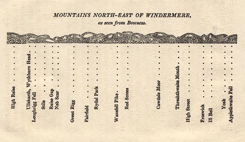 click to enlarge click to enlargeOT2E11.jpg Printed on p.99 of A Concise Description of the English Lakes, by Jonathan Otley, 5th edition, 1834. "MOUNTAINS NORTH-EAST OF WINDERMERE, as seen from Bowness." Mountains are listed:- "High Raise / Ullskarth, Wythburn Head / Loughrigg Fell / Stile / Raise Gap / Nab Scar / Great Rigg / Fairfield / Rydal Park / Wansfell Pike / Red Screes / Cawdale Moor / Threshthwaite Mouth / High Street / Froswick / Ill Bell / Yoak / Applethwaite Fell" item:- JandMN : 48.12 Image © see bottom of page |
|
|
|
||
| evidence:- | descriptive text:- Otley 1823 (5th edn 1834) item:- geology |
|
| source data:- | Print, woodcut outline view, The Mountains of Grasmere and
Rydal, by Jonathan Otley, Keswick, Cumberland, 1830. goto source goto sourcePage 157:- "... and a vein of the same [yellow sulphuret copper ore] was a few years ago opened at Wythburn. ..." item:- JandMN : 48.4 Image © see bottom of page |
|
|
|
||
| evidence:- | outline view:- Otley 1823 (8th edn 1849) placename:- Wythburn Head |
|
| source data:- | Engraving, outline view of mountains, Windermere looking towards the North East from
Bowness, drawn by T Binns, engraved by O Jewitt, opposite p.2 of A Descriptive Guide
of the English Lakes, by Jonathan Otley, 8th edition, 1849.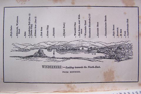 click to enlarge click to enlargeO80E02.jpg With a list of mountains. item:- Armitt Library : A1180.3 Image © see bottom of page |
|
|
|
||
| evidence:- | outline view:- Otley 1823 (8th edn 1849) placename:- Wythburn Head |
|
| source data:- | Engraving, outline view of mountains, Grasmere from Red Bank Head, drawn by T Binns,
engraved by O Jewitt, opposite p.4 of A Descriptive Guide of the English Lakes, by
Jonathan Otley, 8th edition, 1849.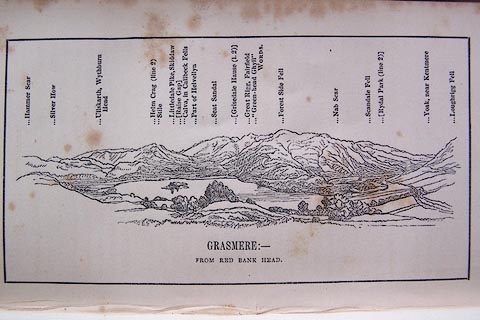 click to enlarge click to enlargeO80E04.jpg item:- Armitt Library : A1180.5 Image © see bottom of page |
|
|
|
||
| evidence:- | outline view:- Jenkinson 1875 placename:- Wythburn Head |
|
| source data:- | Print, lithograph, outline view, Panoramic Sketches from Helvellyn, Westmorland, by
Edwin A Pettitt, London, published by Edward Stanford, 55 Charing Cross, London, 1875. click to enlarge click to enlargeJk01E1.jpg "... Wythburn Head ..." item:- JandMN : 28.5 Image © see bottom of page |
|
|
|
||
 Click to enlarge CBP67.jpg (taken 8.9.2014) |
||
|
|
||
Lakes Guides menu.