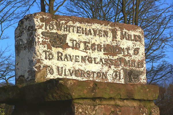


BOJ74.jpg Inscribed stone:-
"TO WHITEHAVEN 11 MILES / [hand] TO EGREMONT 6 / TO RAVENGLASS [5] MILES / TO ULVERSTON 31 [hand]" (taken 7.12.2007)

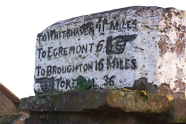
BOJ75.jpg Inscribed stone:-
"TO WHITEHAVEN 11 MILES / TO EGREMONT 6 [hand ] / TO BROUGHTON 16 MILES / [hand] TO [KENDAL] 31" (taken 7.12.2007)
courtesy of English Heritage
"MILESTONE ON WALL TO NORTH WEST OF HIGH SCHOOL HOUSE / / A595 / GOSFORTH / COPELAND / CUMBRIA / II / 76220 / NY0641103711"
courtesy of English Heritage
"Milestone; possibly c1812 when the roads were made up. Monolithic sandstone block placed on top of wall. Trapezoid in plan. c3 ft long and cl ft 3 ins high; painted white with crude incised lettering and outline hands picked out in black. East face (with chamfered edges): TO WHITEHAVEN 11 MILES TO EGREMONT 6 (hand points to right); TO BROUGHTON 16 MILES TO KENDAL 36 (hand points to left). West face: TO WHITEHAVEN 11 MILES TO EGREMONT 6 (hand points to left); TO RAVENGLASS 5 MILES TO ULVERSTON 31 (hand points to right)."

 Lakes Guides menu.