 Old Cumbria Gazetteer
 |
 |
|
| Greenup, Borrowdale | ||
| Greenup | ||
| civil parish:- | Borrowdale (formerly Cumberland) | |
| county:- | Cumbria | |
| locality type:- | valley | |
| coordinates:- | NY27731266 (etc) | |
| 1Km square:- | NY2712 | |
| 10Km square:- | NY21 | |
|
|
||
| evidence:- | old map:- OS County Series (Cmd 70 1) placename:- Greenup |
|
| source data:- | Maps, County Series maps of Great Britain, scales 6 and 25
inches to 1 mile, published by the Ordnance Survey, Southampton,
Hampshire, from about 1863 to 1948. |
|
|
|
||
| evidence:- | old print:- Green 1815 placename:- Greenup Vale item:- sheep |
|
| source data:- | Print, coloured aquatint, Borrowdale from Greenup Vale, Borrowdale, Cumberland, by
William Green, Ambleside, Westmorland, 1815.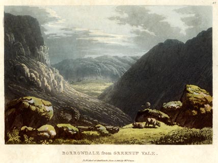 click to enlarge click to enlargeGN0543.jpg Plate 47 in Lake Scenery. printed at upper right:- "47" printed at bottom:- "BORROWDALE from GREENUP VALE. / Published at Ambleside, June 1, 1815, by Wm. Green." item:- Armitt Library : A6646.43 Image © see bottom of page |
|
|
|
||
 Lakes Guides menu.