 Old Cumbria Gazetteer
 |
 |
|
| Latterbarrow, Ennerdale and Kinniside | ||
| Latterbarrow | ||
| civil parish:- | Ennerdale and Kinniside (formerly Cumberland) | |
| county:- | Cumbria | |
| locality type:- | hill | |
| coordinates:- | NY131145 | |
| 1Km square:- | NY1314 | |
| 10Km square:- | NY11 | |
|
|
||
| evidence:- | outline view:- Otley 1823 (8th edn 1849) placename:- Latterbarrow |
|
| source data:- | Engraving, outline view of mountains, Ennerdale from a Field near Kirkland and Salter,
drawn by T Binns, engraved by O Jewitt, opposite p.20 of A Descriptive Guide of the
English Lakes, by Jonathan Otley, 8th edition, 1849.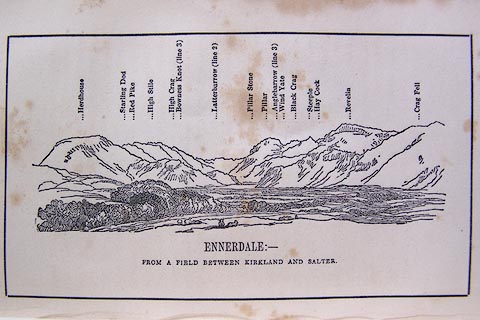 click to enlarge click to enlargeO80E11.jpg item:- Armitt Library : A1180.12 Image © see bottom of page |
|
|
|
||
| evidence:- | outline view:- Matthew 1866 placename:- Patterbarrow |
|
| source data:- | Print, engraving, outline view, Ennerdale, Cumberland, published by J Richardson,
Highgate, Kendal, Westmorland, 1866.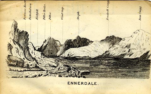 click to enlarge click to enlargeMW1E04.jpg Tipped in before p.1 of The English Lakes, Peaks and Passes, from Kendal to Keswick, by George King Matthew. printed at bottom:- "ENNERDALE" printed at caption to mountains:- "... Patterbarrow. ..." item:- Armitt Library : A1168.4 Image © see bottom of page |
|
|
|
||
| evidence:- | outline view:- Linton 1852 placename:- Latterbarrow |
|
| source data:- | Print, engraving, outline views, Mountains as Seen from the Esk Viaduct, the Eskmeals
Viaduct, and Mountains as Seen from the Viaduct near Drigg, the Irt Viaduct, Whitehaven
and Furness Junction Railway, Cumberland, engraved by W H Lizars, Edinburgh, published
by Whittaker and Co, London, and by R Gibson and Son and by Callander and Dixon, Whitehaven,
Cumberland, 1852.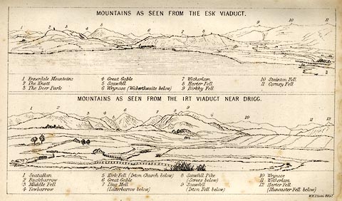 click to enlarge click to enlargeLN1E13.jpg Tipped in opposite p.86 of A Handbook of the Whitehaven and Furness Railway, by John Linton. item:- Armitt Library : A1158.11 Image © see bottom of page |
|
|
|
||
 Lakes Guides menu.