 Old Cumbria Gazetteer
 |
 |
|
| High Mill, Garnett Bridge | ||
| High Mill | ||
| Sleddalefoot Mill | ||
| Wilson Mill | ||
| site name:- | Sprint, River | |
| locality:- | Garnett Bridge | |
| civil parish:- | Strickland Roger (formerly Westmorland) | |
| county:- | Westmorland | |
| locality type:- | mill | |
| locality type:- | water mill | |
| locality type:- | bobbin mill | |
| coordinates:- | SD52149970 | |
| 1Km square:- | SD5299 | |
| 10Km square:- | SD59 | |
|
|
||
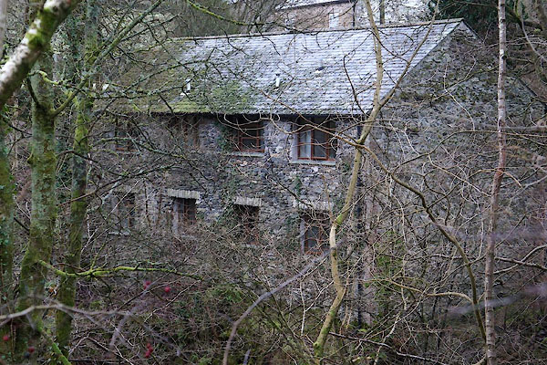 CEL90.jpg (taken 1.1.2016) |
||
|
|
||
| evidence:- | old map:- OS County Series (Wmd 33 4) placename:- Sleddalefoot Mill |
|
| source data:- | County Series map, Westmorland sheet 33 4, part of Longsleddale, Westmorland, scale
25 inches to 1 mile, published by the Ordnance Survey, Southampton, Hampshire, about
1890s?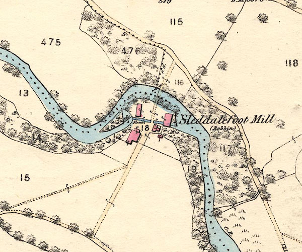 BNJ81.jpg item:- private collection : 55 Image © see bottom of page "Sleddalefoot Mill (Bobbins)" |
|
|
|
||
| evidence:- | old map:- OS County Series (Wmd 33 4) placename:- High Mill |
|
| source data:- | Maps, County Series maps of Great Britain, scales 6 and 25
inches to 1 mile, published by the Ordnance Survey, Southampton,
Hampshire, from about 1863 to 1948. County Series 25 inch map, Westmorland sheet XXXIII 4, surveyed 1858-59, revised 1896, 2nd edition published by Ordnance Survey, 1898. "High Mill" |
|
|
|
||
| notes:- |
Called Wilson Mill on the plans of the Kendal Reservoir Commissioners. Worked by Robert
Seed, bobbin turner, Longsleddale, 1827; later by William Bethom; later by Muncaster
and Martindale. |
|
| Sumervell, John: 1930: Water Power Mills of South Westmorland |
||
|
|
||
 Lakes Guides menu.