 Old Cumbria Gazetteer
 |
 |
|
| Brough Mill, Brough | ||
| Brough Mill | ||
| site name:- | Swindale Beck (3) | |
| locality:- | Brough | |
| civil parish:- | Brough (formerly Westmorland) | |
| county:- | Cumbria | |
| locality type:- | water mill | |
| locality type:- | mill | |
| coordinates:- | NY79481450 (guess) | |
| 1Km square:- | NY7914 | |
| 10Km square:- | NY71 | |
| references:- | Lowther 1780s-90s |
|
|
|
||
| evidence:- | old map:- Jefferys 1770 (Wmd) |
|
| source data:- | Map, 4 sheets, The County of Westmoreland, scale 1 inch to 1
mile, surveyed 1768, and engraved and published by Thomas
Jefferys, London, 1770.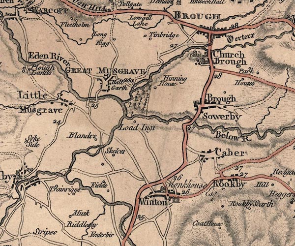 J5NY71SE.jpg circle with rays; water mill item:- National Library of Scotland : EME.s.47 Image © National Library of Scotland |
|
|
|
||
| evidence:- | descriptive text:- Lowther 1780s-90s placename:- Brough Mill |
|
| source data:- | Scrapbook, 4 volumes, of descriptive texts, maps, and prints of
views and coats of arms, for Westmorland and Cumberland,
assembled by a member of the Lowther Family, late 18th early
19th century. Text with a print, engraving, Brough Castle, drawn by Samuel Hooper, engraved by Sparrow, 1775:- "BROUGH CASTLE, WESTMORELAND." "..." "THE present proprietor of these ruins is the Earl of Thanet. Of late years they have been much demolished for the sake of the materials, which have been used in building stables, garden walls, and other conveniences; and particularly about the year 1763, a great part of the north-east round tower was pulled down to repair Brough Mill, at which time the Mason therein employed, for the sake of the lead and iron with which it was fixed, displaced the stone which the Countess of Pembroke caused to be set over the gateway, on which was the inscription before cited." |
|
|
|
||
 Lakes Guides menu.