 Old Cumbria Gazetteer
 |
 |
|
| Dale End Bridge, Longsleddale | ||
| Dale End Bridge | ||
| site name:- | Sprint, River | |
| locality:- | Longsleddale | |
| civil parish:- | Longsleddale (formerly Westmorland) | |
| county:- | Cumbria | |
| locality type:- | packhorse bridge (?) | |
| locality type:- | bridge | |
| coordinates:- | NY51630010 | |
| 1Km square:- | NY5100 | |
| 10Km square:- | NY50 | |
|
|
||
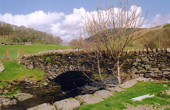 BIP33.jpg (taken 22.4.2004) |
||
|
|
||
| evidence:- | old map:- Hodgson 1828 |
|
| source data:- | Map, hand coloured engraving, 4 sheets mounted together on linen and rolled, Plan
of the County of Westmorland, scale about 1.25 inches to 1 mile, by Thomas Hodgson,
engraved by W R Gardner, Harpur Street, London, published by Thomas Hodgson, Lancaster,
and perhaps by C Smith, 172 Strand, London,1828.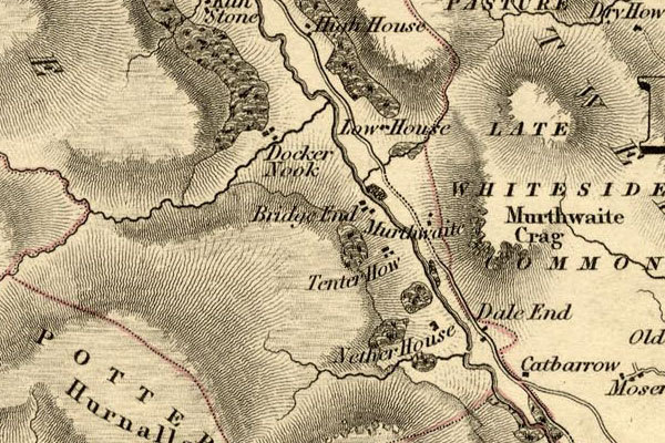 HDG6lsl1.jpg map courtesy of Mark Cropper item:- private collection : 371 Image © see bottom of page |
|
|
|
||
| evidence:- | probably records:- Curwen 1926 placename:- Dale End Bridge |
|
| source data:- | Records Relating to the Barony of Kendale, supplementary vol.3,
edited by John F Curwen, published by Titus Wilson and Son,
Kendal, Westmorland, 1926. CURWEN01.txt "1749/50 January 12 : Presentment that Dale End Bridge in the King's highway from the township of Longsleddale to the market town of K. Kendale upon the River Sprint is in such decay for want of rebuilding the same, and further that Mary Gibson, widow, Thomas Hudson, yeo., Alice Collinson, widow, Christopher Todd, yeo., John Harrison, yeo., all of Longsledddale, and Tho. Field of Flookborough, clerk, James Garnet of Underbarrow, yeo., John Richardson of Coldbeck, yeo., by reason of their tenure of certain lands adjoining the said highway ought to amend and rebuild the said bridge. (A. and K. Indictment Book, 1738-50). Upon the presentation that the bridge was rebuilt and in good and sufficient repair at the court held 27 April, 1750, the order was discharged. Ibid." |
|
|
|
||
| evidence:- | descriptive text:- |
|
| source data:- | Royal Commission on Historical Monuments in England: 1936: Inventory of the Historical
Monuments in Westmorland: HMSO "BRIDGE, over the River Sprint, near the S. edge of the parish, is a rubble structure
of one span with a wide segmental arch. It was built perhaps in the 17th century as
a pack-horse bridge and was subsequently widened on the S. side." |
|
|
|
||
| evidence:- | database:- Listed Buildings 2010 |
|
| source data:- | courtesy of English Heritage "BRIDGE OVER RIVER SPRINT SOUTH EAST OF NETHER HOUSE / / / LONGSLEDDALE / SOUTH LAKELAND / CUMBRIA / II / 76402 / NY5163100100" |
|
| source data:- | courtesy of English Heritage "Bridge probably built as packhorse bridge during C17 and widened on the South side later. Rubble with stone copings and single segmental arch. RCHM p. 157." |
|
|
|
||
 Lakes Guides menu.