 Old Cumbria Gazetteer
 |
 |
|
| viewpoint, Pooley Bridge | ||
| locality:- | Pooley Bridge | |
| civil parish:- | Barton (formerly Westmorland) | |
| county:- | Cumbria | |
| locality type:- | viewpoint | |
| coordinates:- | NY47002442 (about) | |
| 1Km square:- | NY4724 | |
| 10Km square:- | NY42 | |
|
|
||
| evidence:- | outline view:- Otley 1823 (4th edn 1830) |
|
| source data:- | Print, engraving, outline view, The Mountains of Ullswater as seen from Pooley Bridge,
published by Jonathan Otley, Keswick, Cumberland et al, 1830.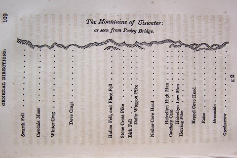 click to enlarge click to enlargeO75E05.jpg p.109 in A Concise Description of the English Lakes, by Jonathan Otley, 4th edition, 1830. printed at top:- "The Mountains of Ulswater: / as seen from Pooley Bridge." printed at bottom:- "Swarth Fell / Cawdale Moor / Winter Crag / Dove Crags / Hallen Fell, and Place Fell / Stone Cross Pike / Birk Fell / Dolly Waggon Pike / Nether Cove Head / Helvellyn High Man / Catchety Cam / Helvellyn Low Man / Herring Pike / Keppel Cove Head / Raise / Greenside / Gowbarrow" item:- Armitt Library : A1175.5 Image © see bottom of page |
|
|
|
||
| evidence:- | outline view:- Otley 1823 (5th edn 1834) |
|
| source data:- | Print, woodcut outline view, Mountains of Ullswater, by Jonathan Otley, Keswick, Cumberland
now Cumbria, 1834.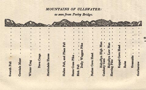 click to enlarge click to enlargeOT2E12.jpg Printed on p.113 of A Concise Description of the English Lakes, by Jonathan Otley, 5th edition, 1834. printed at top:- "MOUNTAINS OF ULLSWATER: / as seen from Pooley Bridge." printed at bottom:- "Swarth Fell / Cawdale Moor / Winter Crag / Dove Crags / Martindale Hause / Hallen Fell, and Place Fell / Stone Cross Pike / Birk Fell / Dolly Waggon Pike / Nether Cove Head / Helvellyn High Man / Catchety Cam / Helvellyn Low Man / Herring Pike / Keppel Cove Head / Raise / Greenside / Gowbarrow" item:- JandMN : 48.13 Image © see bottom of page |
|
|
|
||
| evidence:- | outline view:- Otley 1823 (8th edn 1849) |
|
| source data:- | Print, engraving, outline view of mountains, Ullswater from Pooley Bridge, drawn by
Mr Binns, Halifax, engraved by Mr Jewitt, Headington, Oxfordshire, published by Jonathan
Otley, Keswick, Cumberland et al, 1849.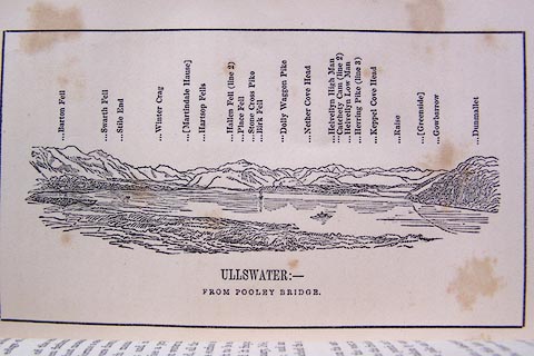 click to enlarge click to enlargeO80E07.jpg Opposite p.12 of A Descriptive Guide of the English Lakes, by Jonathan Otley, 8th edition, 1849. printed at bottom:- "ULLSWATER: - / FROM POOLEY BRIDGE." printed at top:- "Barton Fell / Swarth Fell / Stile End / Winter Crag / (Martindale Hause) / Hartsop Fells / Hallen Fell (line 2) / Place Fell / Stone Cross Pike / Birk Fell / Dolly Waggon Pike / Nether Cove Head / Helvellyn High Man / Catchety Cam (line 2) / Helvellyn Low Man / Herring Pike (line 2) / Keppel Cove Head / Raise / (Greenside) / Gowbarrow / Dunmallet" Looking SW; 115 degree view, S to ENE. item:- Armitt Library : A1180.8 Image © see bottom of page |
|
|
|
||
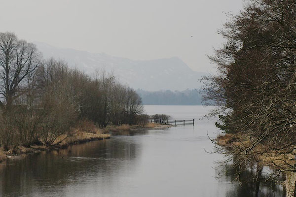 BYB99.jpg View from the bridge to the lake. (taken 4.1.2006) |
||
|
|
||
 Lakes Guides menu.