 Old Cumbria Gazetteer
 |
 |
|
| viewpoint, Nether Wasdale | ||
| locality:- | Nether Wasdale | |
| civil parish:- | Nether Wasdale (formerly Cumberland) | |
| county:- | Cumbria | |
| locality type:- | viewpoint | |
| coordinates:- | NY125044 | |
| 1Km square:- | NY1204 | |
| 10Km square:- | NY10 | |
|
|
||
| evidence:- | outline view:- Otley 1823 (4th edn 1830) |
|
| source data:- | Print, engraving, outline view, Mountains round Wastwater as seen from the Strands
in Nether Wasdale, published by Jonathan Otley, Keswick, Cumberland et al, 1830.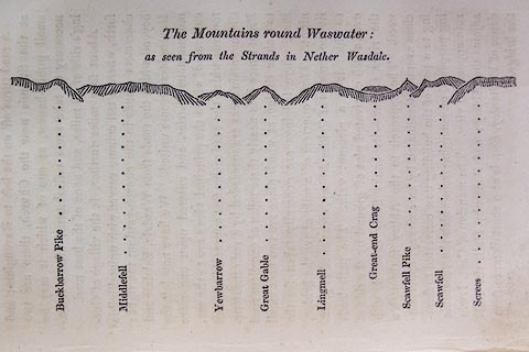 click to enlarge click to enlargeO75E08.jpg p.129 in A Concise Description of the English Lakes, by Jonathan Otley, 4th edition, 1830. printed at top:- "The Mountains round Wastwater: / as seen from the Strands in Nether Wasdale." printed at bottom:- "Buckbarrow Pike / Middlefell / Yewbarrow / Great Gable / Lingmell / Great-end Crag / Scawfell Pike / Scawfell / Screes" item:- Armitt Library : A1175.8 Image © see bottom of page |
|
|
|
||
| evidence:- | outline view:- Otley 1823 (5th edn 1834) |
|
| source data:- | Print, woodcut outline view, Mountains of Wast Water, by Jonathan Otley, Keswick,
Cumberland now Cumbria, 1834.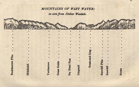 click to enlarge click to enlargeOT2E07.jpg Printed on p.31 of A Concise Description of the English Lakes, by Jonathan Otley, 5th edition, 1834. printed at top:- "MOUNTAINS OF WAST WATER: / as seen from Nether Wasdale." printed at bottom:- "Buckbarrow Pike / Middlefell / Yewbarrow / Great Gable / Sty Head Pass / Lingmell / Great-end Crag / Scawfell Pike / Scawfell / Screes" item:- JandMN : 48.8 Image © see bottom of page |
|
|
|
||
| evidence:- | outline view:- Otley 1823 (8th edn 1849) |
|
| source data:- | Print, engraving, outline view of mountains, Mountains of Wast Water as seen from
Nether Wasdale, drawn by Mr Binns, Halifax, engraved by Mr Jewitt, Headington, Oxfordshire,
published by Jonathan Otley, Keswick, Cumberland et al, 1849.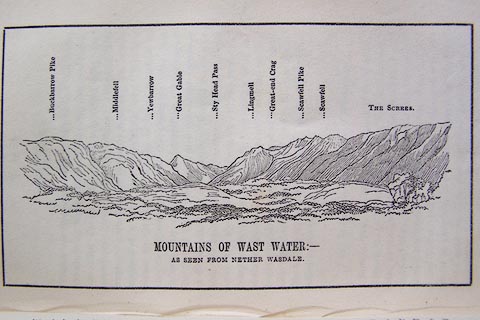 click to enlarge click to enlargeO80E13.jpg Opposite p.22 of A Descriptive Guide of the English Lakes, by Jonathan Otley, 8th edition, 1849. printed at bottom:- "MOUNTAINS OF WAST WATER: - / AS SEEN FROM NETHER WASDALE." printed at top:- "Buckbarrow Pike / Middlefell / Yewbarrow / Great Gable / Sty Head Pass / Lingmell / Great-end Crag / Scawfell Pike / Scawfell / THE SCREES." Looking NEbyE; 60 degree view, NNE to EbyN. item:- Armitt Library : A1180.14 Image © see bottom of page |
|
|
|
||
| evidence:- | outline view:- Red Guide 1892 |
|
| source data:- | Print, engraving, pair of outline views, Mountains as seen from Low Wood Inn, and
Mountains as seen from the Elevation on the Road opposite the Inn at Strands in Wasdale,
published by Ward, Lock and Co, Warwick House, Salisbury Square, London, etc, 1892.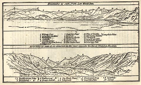 click to enlarge click to enlargeRG0101.jpg "1 Buckbarrow Pike 2 Middlefell 3 Yewbarrow 4 Great Gable 5 Sty Head Pass 6 Lingmell 7 Great-end Crag 8 Scawfell Pike 9 Scawfell 10 Screes" On p.72 in the Red Guide guide book, Guide to the English Lakes. item:- JandMN : 102.2 Image © see bottom of page |
|
|
|
||
 Lakes Guides menu.