 Old Cumbria Gazetteer
 |
 |
|
| Cold Keld Wyke, Buttermere | ||
| Cold Keld Wyke | ||
| site name:- | Crummock Water (?) | |
| civil parish:- | Buttermere (formerly Cumberland) (?) | |
| civil parish:- | Loweswater (formerly Cumberland) (?) | |
| county:- | Cumbria | |
| locality type:- | bay (?) | |
| coordinates:- | NY152207 (?) | |
| 1Km square:- | NY1520 | |
| 10Km square:- | NY12 | |
| references:- | Otley 1823 |
|
|
|
||
| evidence:- | outline view:- Otley 1823 (4th edn 1830) placename:- Cold Kell Wyke |
|
| source data:- | Print, engraving, outline view, The Mountains of Crummock and Buttermere as seen on
the Road between Scale-Hill and Loweswater, published by Jonathan Otley, Keswick,
Cumberland et al, 1830.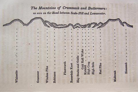 click to enlarge click to enlargeO75E07.jpg p.125 in A Concise Description of the English Lakes, by Jonathan Otley, 4th edition, 1830. "The Mountains of Crummock and Buttermere: / as seen on the Road between Scale-Hill and Loweswater." "Whiteside / Grasmoor / Witeless Pike / Robinson / Fleetworth / Rannerdale Knot / Hay Stacks and Gable / Cold Kell Wyke / Kirkfell / High Crag / High Stile / Red Pike / Melbreak / Hencomb" item:- Armitt Library : A1175.7 Image © see bottom of page |
|
|
|
||
| evidence:- | outline view:- Otley 1823 (5th edn 1834) |
|
| source data:- | Print, woodcut outline view, The Mountains of Crummock and
Buttermere, by Jonathan Otley, Keswick, Cumberland, 1830.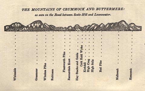 click to enlarge click to enlargeOT2E05.jpg Printed on p.25 of A Concise Description of the English Lakes, by Jonathan Otley, 5th edition, 1834. "THE MOUNTAINS OF CRUMMOCK AND BUTTERMERE: as seen on the Road between Scale-Hill and Loweswater." "Whiteside / Grasmoor / Witeless Pike / Robinson / Fleetworth Pike / Rannerdale Knot / Hay Stacks and Gable / Cold Keld Wyke / Kirkfell / High Crag / High Stile / Red Pike / Melbreak / Hencomb" item:- JandMN : 48.6 Image © see bottom of page |
|
|
|
||
 Lakes Guides menu.