 Old Cumbria Gazetteer
 |
 |
|
| railway tunnel, Little Strickland | ||
| gone? | ||
| site name:- | Lancaster and Carlisle Railway | |
| civil parish:- | Little Strickland (formerly Westmorland) | |
| county:- | Cumbria | |
| locality type:- | railway tunnel | |
| coordinates:- | NY55841873 (guess) | |
| 1Km square:- | NY5518 | |
| 10Km square:- | NY51 | |
| SummaryText:- | This tunnel is not found on other maps. | |
| references:- | LMS 1920s maps |
|
|
|
||
| evidence:- | old map:- LMS 1920s maps |
|
| source data:- | Railway map, lithograph, 23 pages of strip maps, The Journey in
Brief, the Route London to Carlisle, published by the London
Midland and Scottish Railway, LMS, 1920s.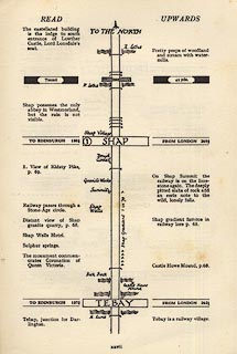 click to enlarge click to enlargeLS3p27.jpg "Tunnel / 45 yds." Just north of the first crossing of the River Leith. item:- JandMN : 95.2 Image © see bottom of page |
|
|
|
||
 Lakes Guides menu.