 Old Cumbria Gazetteer
 |
 |
|
| milestone, Casterton | ||
| site name:- | road, Kirkby Lonsdale to Sedbergh | |
| civil parish:- | Casterton (formerly Westmorland) | |
| county:- | Cumbria | |
| locality type:- | milestone | |
| coordinates:- | SD62468012 | |
| 1Km square:- | SD6280 | |
| 10Km square:- | SD68 | |
|
|
||
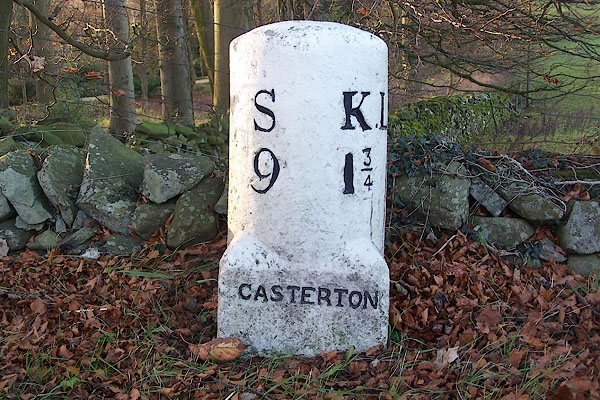 BNB47.jpg Inscribed stone:- "S 9 / KL 1¾/ CASTERTON" (taken 1.12.2006) |
||
|
|
||
| evidence:- | old map:- OS County Series (Wmd 48 1) |
|
| source data:- | Maps, County Series maps of Great Britain, scales 6 and 25
inches to 1 mile, published by the Ordnance Survey, Southampton,
Hampshire, from about 1863 to 1948. "M.S. Kirkby Lonsdale .. 1 3/4 Sedbergh .. 9" |
|
|
|
||
| evidence:- | database:- Listed Buildings 2010 |
|
| source data:- | courtesy of English Heritage "MILESTONE BY THE GRANGE / / A683 / CASTERTON / SOUTH LAKELAND / CUMBRIA / II / 75610 / SD6246380122" |
|
| source data:- | courtesy of English Heritage "Milestone. Probably early C19. Painted stone. Semicircular on plan, on square base with broaches. Inscribed: "S:K.L./9:l3/4", and on base: "CASTERTON". Set on Sedbergh to Greta Bridge turnpike road, 1762." |
|
|
|
||
| evidence:- | database:- Listed Buildings 2010 |
|
| source data:- | courtesy of English Heritage "MILESTONE APPROXIMATELY 90M SOUTH OF THE A683 (SOUTH) JUNCTION / / A65 / CASTERTON / SOUTH LAKELAND / CUMBRIA / II / 75607 / SD6198577905" |
|
| source data:- | courtesy of English Heritage "Milestone. Probably early C19. Dressed stone. Triangular stone with chamfered front angle. Inscribed with the figures: 1 (mile to Kirkby Lonsdale) and 16 (miles to Settle)." |
|
|
|
||
 Lakes Guides menu.