 Old Cumbria Gazetteer
 |
 |
|
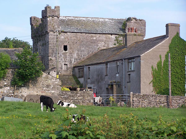
| Wraysholme Tower, Lower Allithwaite | ||
| Wraysholme Tower | ||
| civil parish:- | Lower Allithwaite (formerly Lancashire) | |
| county:- | Cumbria | |
| locality type:- | tower | |
| coordinates:- | SD38337544 | |
| 1Km square:- | SD3875 | |
| 10Km square:- | SD37 | |
|
|
||
 BJM96.jpg (taken 6.6.2005) |
||
|
|
||
| evidence:- | old map:- OS County Series (Lan 17 11) placename:- Wraysholme Tower |
|
| source data:- | Maps, County Series maps of Great Britain, scales 6 and 25
inches to 1 mile, published by the Ordnance Survey, Southampton,
Hampshire, from about 1863 to 1948. |
|
|
|
||
| evidence:- | old map:- Ford 1839 map placename:- Wraysholme Tower |
|
| source data:- | Map, uncoloured engraving, Map of the Lake District of
Cumberland, Westmoreland and Lancashire, scale about 3.5 miles
to 1 inch, published by Charles Thurnam, Carlisle, and by R
Groombridge, 5 Paternoster Row, London, 3rd edn 1843.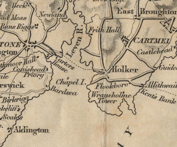 FD02SD37.jpg "Wraysholme Tower" item:- JandMN : 100.1 Image © see bottom of page |
|
|
|
||
| evidence:- | old print:- Curwen 1913 placename:- Wraysholme Tower |
|
| source data:- | Print, halftone photograph, Wraysholme Tower, Lower Allithwaite, Lancashire, published
for the Cumberland and Westmorland Antiquarian and Archaeological Society by Titus
Wilson, Kendal, Westmorland, 1913.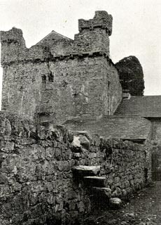 click to enlarge click to enlargeCW0186.jpg Tipped in opposite p.407 of The Castles and Fortified Towers of Cumberland, Westmorland, and Lancashire North of the Sands, by John F Curwen. printed at bottom:- "WRAYSHOLME TOWER from the North" item:- Armitt Library : A782.86 Image © see bottom of page |
|
|
|
||
| evidence:- | old print:- Curwen 1913 placename:- Wraysholme Tower |
|
| source data:- | Print, halftone photograph, Wraysholme Tower, Lower Allithwaite, Lancashire, published
for the Cumberland and Westmorland Antiquarian and Archaeological Society by Titus
Wilson, Kendal, Westmorland, 1913.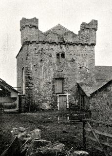 click to enlarge click to enlargeCW0187.jpg Tipped in opposite p.407 of The Castles and Fortified Towers of Cumberland, Westmorland, and Lancashire North of the Sands, by John F Curwen. printed at bottom:- "WRAYSHOLME TOWER from the North" item:- Armitt Library : A782.87 Image © see bottom of page |
|
|
|
||
| evidence:- | database:- Listed Buildings 2010 placename:- Wraysholme Tower |
|
| source data:- | courtesy of English Heritage "WRAYSHOLME TOWER / / WRAYSHOLME LANE / LOWER ALLITHWAITE / SOUTH LAKELAND / CUMBRIA / II[star] / 77025 / SD3831875420" |
|
| source data:- | courtesy of English Heritage "Peel tower, now barn over cowhouse. Probably late C15. Dressed stone with slate roof. Square tower, originally of 3 storeys, 1st floor now rises to gabled roof. North elevation has corbelled parapet, some corbels pierced to form water spouts, and angle turrets with corbelled embattled parapets, both damaged to south side. Large C20 building attached, and 2nd floor flat-headed window of 2 cusped lights. East elevation has entrance with rough head and small window to right, probably both inserted. 1st floor has hollow chamfered light, and large inserted entrance, approached by ramp and bridge, to north end. 2nd floor has 2 hollow-chamfered lights. South elevation has projecting garderobe to east end, rising to full height, the turret now missing, but with traces of corralling to returns; small lights to west return. Ground floor has chamfered light and lean-to privy next to garderobe turret; 1st floor has flat-headed window, originally of 2 cusped lights but mullion missing; 2nd floor has flat-headed window of 2 cusped lights; corbelled parapet and gable, remains of turret to west angle. West facade has attached farmhouse (datestones of C17 and C19, much altered). Stair lights to south end. Pointed entrance to north end has hollow chamfered opening and jamb missing; hollow chamfered light to each floor above. Pointed entrance, now leading to house opens onto lobby, with spiral stair in south-west angle; pointed entrance to main space. Ground floor has cowhouse partitions. Stair has straight-headed entrance with hollow chamfered reveals to each floor; Tudor-headed fireplace to each floor, that to ground floor now window. A good example of peel tower unaltered by post-medieval domestic use. A Scheduled Ancient Monument." |
|
|
|
||
| hearsay:- |
Perhaps 15th century pele, 19th century farmhouse. |
|
|
|
||
| hearsaystory:- |
John Harrington, son of Sir Edgar Harrington, fell in love with his father's ward,
Adela. His father disinherited John who set off to the Crusades. Returning, John heard
that a wolf had been ravaging the district and that his father had offered Adela's
hand in marriage to anyone who could kill the wolf. So, naturally, John slew the wolf,
on Humphrey Head, and claimed Adela and his inheritance. |
|
| The wolf is said to have been the last wolf. |
||
|
|
||
| notes:- |
15th century tower and later hall |
|
| Perriam, D R &Robinson, J: 1998: Medieval Fortified Buildings of Cumbria: CWAAS::
ISBN 1 873124 23 6; plan and illustration |
||
|
|
||
 Lakes Guides menu.