 Old Cumbria Gazetteer
 |
 |
|
| Witches' Holes, Lancashire | ||
| Witches' Holes | ||
| Witches Cave | ||
| site name:- | Gragareth | |
| county:- | Lancashire | |
| locality type:- | pothole | |
| locality type:- | cave | |
| coordinates:- | SD660799 | |
| 1Km square:- | SD6679 | |
| 10Km square:- | SD67 | |
| altitude:- | 715 feet | |
| altitude:- | 218m | |
| SummaryText:- | Grade I; permission from Council of Northern Caving Clubs. | |
| references:- | Balderston c1890 Brook, D & Davies, G & Long, M H &Sutcliffe, J R: 1975: Northern Caves, vol.4 Whernside and Gragareth: Dalesman Books:: ISBN 0 85206 259 1 |
|
|
|
||
| evidence:- | descriptive text:- Otley 1823 (8th edn 1849) placename:- Witch Holes |
|
| source data:- | Guide book, A Concise Description of the English Lakes, the
mountains in their vicinity, and the roads by which they may be
visited, with remarks on the mineralogy and geology of the
district, by Jonathan Otley, published by the author, Keswick,
Cumberland now Cumbria, by J Richardson, London, and by Arthur
Foster, Kirkby Lonsdale, Cumbria, 1823; published 1823-49,
latterly as the Descriptive Guide to the English Lakes. goto source goto sourcePage 192:- "..." "There is a cavern called the WITCH HOLES, about 300 yards from the entrance to the gill [Easegill]. It is easy of access, and continues for a long way into the mountain; but, after proceeding about 80 yards, we are stopped by a pool of water. To the right of the entrance there is a singular thin plate of limestone, called 'the Witches' staircase;' on climbing which, you find yourself in a small apartment, all glittering with innumerable crystals. ..." |
|
|
|
||
| evidence:- | descriptive text:- Balderston c1890 placename:- Witches' Holes |
|
| source data:- | Book, Ingleton, Bygone and Present, by Robert R and Margaret
Balderston, published by Simpkin, Marshall and Co, London, and
by Edmndson and Co, 24 High Street, Skipton, Yorkshire, about
1890. goto source page 66:- "..." "The Witches' Holes." "Scaling the ridge of Greygareth, or if proceeding directly from Ingleton, passing through Ireby, there are found on the other side of the mountain more wonders such as Bull Pot, Gavel Pot, and Rumbling Hole; but it is to Ease Gill Kirk and Foss, and last, though by no means least, the Witches' Cave or Holes, we must direct our steps. We have twice visited these places, yet before making any remarks, will give an interesting extract from the Lonsdale Magazine for the year 1820, referring to the Witches' Cave or Holes, wherein the writer says:- 'In order to induce the timid reader to follow me, it may not be improper to assure him on the word of a traveller, that all the witches which formerly haunted this dirty, gloomy cavern, are either dead or banished to the Highlands of Scotland, where they frequently cross the path of a Scott or a Hogg.['] This cave is nothing but creaks and crannies among the loose strata of the limestone; he then adds 'that he met a rustic near the place, and addressed him thus:- 'Pray friend,' said I, 'whence has this dismal spot acquired the title of Witches' Hole?' The old man leaned" goto sourcepage 67:- "upon his rural trident and replied:- 'Ye mebbe doant believe e witches?' He suspended his voice without bringing it to a close; keeping his droll phiz firmly fixed upon us, as much as to require an answer without having strictly asked a question. It is unfashionable to believe in any kind of witches, except the Lancashire Witches - lads love them! I therefore, equivocated; 'I never saw any witches,' said I, 'but this is no proof of their non-existence.' 'Wyah,' said the old man, 'I never sa' any witches mesell, but me grandmuddar said at a parshall a witches ust ta meet yance a ear e thor hoals, an mead a girt feast, an neabudy mud gang tull it, but sic as ther sels.' 'Hence,' said I, 'you suppose it obtained the name of the Witches' Holes.' 'It's varra likely,' said our informant.'" "In describing the place itself, the same writer remarks:- 'To the right we found a pool of water, to the left a pool of mud, in the middle a mixture of both. Proceeding further, as inveterate cave-hunters ought to do, we found the roof sunk to about two feet and a half high, but quickly (raised) again to the height of seven or eight yards,' - not nearly so much. 'In this apartment we let down a line of four or five yards long' - we tried two niches, the deepest being eight feet - 'into the watery cavern below - we preferred this plan to inspecting the cellar personally, as the witches had left it full of water. From this place we crept through another of Howsman's irregular arches; we now found ourselves in an apartment of larger dimensions, pretty lofty and of an even surface, but our further progress was unceremoniously obstructed by a deep, black pool, which occupied the farther extremity of the cave. The low beetling rock sunk to within a few inches of the water and prevented our entrance to the cave, as long as fancy had a mind to constrict it. This pool is about eighty yards from the mouth' - not seventy. ..." |
|
|
|
||
| evidence:- | old map:- Balderston c1890 map placename:- Witches Cave |
|
| source data:- | Map, the hills in the Ingleton area, probably by Robert R
Balderston, engraved by Goodall and Suddick, Leeds, West
Yorkshire, about 1890.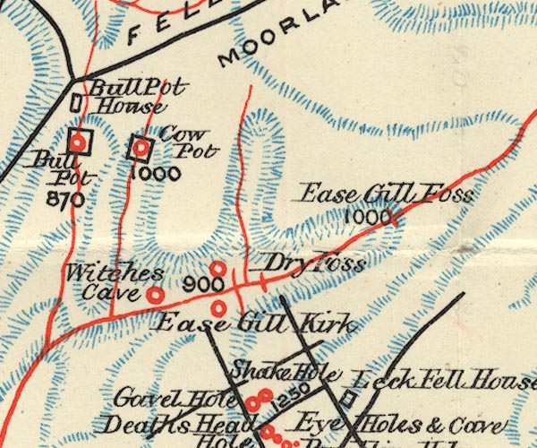 BS1SD68Q.jpg "Witches Cave" item:- private collection : 27.1 Image © see bottom of page |
|
|
|
||
Lakes Guides menu.