 Old Cumbria Gazetteer
 |
 |
|
||||||||||||
| Whinlatter Pass, Lorton | ||||||||||||||
| Whinlatter Pass | ||||||||||||||
| site name:- | road, Keswick to Cockermouth | |||||||||||||
| civil parish:- | Lorton (formerly Cumberland) | |||||||||||||
| county:- | Cumbria | |||||||||||||
| locality type:- | pass | |||||||||||||
| coordinates:- | NY19172457 (etc) | |||||||||||||
| 1Km square:- | NY1924 | |||||||||||||
| 10Km square:- | NY12 | |||||||||||||
|
|
||||||||||||||
| evidence:- | old map:- Donald 1774 (Cmd) placename:- Whinlatter |
|||||||||||||
| source data:- | Map, hand coloured engraving, 3x2 sheets, The County of Cumberland, scale about 1
inch to 1 mile, by Thomas Donald, engraved and published by Joseph Hodskinson, 29
Arundel Street, Strand, London, 1774.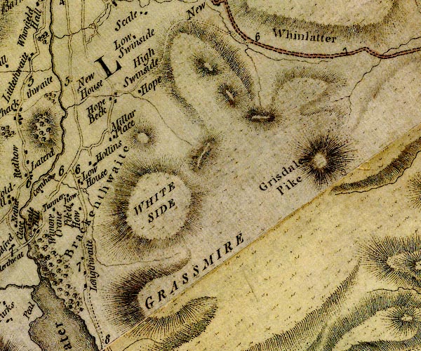 D4NY12SE.jpg "Whinlatter" area between hachures, a pass item:- Carlisle Library : Map 2 Image © Carlisle Library |
|||||||||||||
|
|
||||||||||||||
| evidence:- | old map:- Otley 1818 placename:- Whinlatter |
|||||||||||||
| source data:- | Map, uncoloured engraving, The District of the Lakes,
Cumberland, Westmorland, and Lancashire, scale about 4 miles to
1 inch, by Jonathan Otley, 1818, engraved by J and G Menzies,
Edinburgh, Scotland, published by Jonathan Otley, Keswick,
Cumberland, et al, 1833.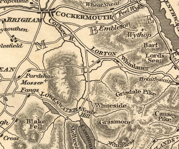 OT02NY12.jpg item:- JandMN : 48.1 Image © see bottom of page |
|||||||||||||
|
|
||||||||||||||
| evidence:- | descriptive text:- Otley 1823 (5th edn 1834) |
|||||||||||||
| source data:- | Guide book, A Concise Description of the English Lakes, the
mountains in their vicinity, and the roads by which they may be
visited, with remarks on the mineralogy and geology of the
district, by Jonathan Otley, published by the author, Keswick,
Cumberland now Cumbria, by J Richardson, London, and by Arthur
Foster, Kirkby Lonsdale, Cumbria, 1823; published 1823-49,
latterly as the Descriptive Guide to the English Lakes. goto source goto sourcePage 128:- "DRIVE TO SCALE HILL, AND BUTTERMERE." "... the old road towards Cockermouth over the steep mountain Whinlatter, which in the length of two miles rises to the height of 800 feet above the valley. ..."
|
|||||||||||||
|
|
||||||||||||||
| evidence:- | descriptive text:- Ford 1839 (3rd edn 1843) placename:- Whinlatter |
|||||||||||||
| source data:- | Guide book, A Description of Scenery in the Lake District, by
Rev William Ford, published by Charles Thurnam, Carlisle, by W
Edwards, 12 Ave Maria Lane, Charles Tilt, Fleet Street, William
Smith, 113 Fleet Street, London, by Currie and Bowman,
Newcastle, by Bancks and Co, Manchester, by Oliver and Boyd,
Edinburgh, and by Sinclair, Dumfries, 1839. goto source Page 92:- "..." "The road over Whinlatter presents some grand views of Bassenthwaite and Derwent Water, Grisdale Pike keeping you company on the right for some distance. On the top of the road, Thornthwaite village and Jenkin Hill, flanked right and left by Longside and Dodd, and Thornthwaite Fell, with Bassenthwaite Water overtopped by Binsey, is the first prospect that stops you. A little further on, Derwent Water, with Vicar's Island, Lord's Island, the Isthmus, and Keswick, are seen lying beneath Wallow Crag, Falcon Crag, and Bleabury Fell; over which rise Skiddaw, Saddleback, Mell Fell, Wanthwaite Crag, St. John's Dodd, Stybarrow Dodd, Styx, and Helvellyn. The road proceeds through Braithwaite to Keswick." |
|||||||||||||
|
|
||||||||||||||
| evidence:- | outline view:- Red Guide 1892 |
|||||||||||||
| source data:- | Print, engraving, pair of outline views, Mountains as seen from Whinlatter, and Mountains
as seen from the Road from Scale Hill to Loweswater, near the Mile Post, published
by Ward, Lock and Co, Warwick House, Salisbury Square, London, etc, 1892.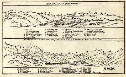 click to enlarge click to enlargeRG0104.jpg "1 Skiddaw / Carlside (below) / Dodd (still lower) 2 Carsledham (below) 3 Skiddaw Low Man 4 Jenkin Hill 6 Lonscale Fell 7 Saddleback 8 Latrigg 9 Little Melfell 10 Setnalinaing 11 Great Dod / St John's Ridge (below) 12 Watson Dod / Wallow Crag (belwo) 13 Stybarrow Dod 14 Whiteside 15 Helvellyn Low Man / Bleaberry Fell (below) / Falcon Crag (Still lower) 16 Eagle Crag 17 High Seat" On p.158 in the Red Guide guide book, Guide to the English Lakes. item:- JandMN : 102.5 Image © see bottom of page |
|||||||||||||
|
|
||||||||||||||
| evidence:- | old print:- Black 1856 (23rd edn 1900) placename:- Whinlatter Gap |
|||||||||||||
| source data:- | Print, lithograph, Outline Views, Skiddaw and Derwent Water - Mountains as seen at
Lodore Hotel, and Mountains as seen at the Third Gate on Ascending Latrigg on the
Way to Skiddaw, by J Flintoft, Keswick, Cumberland, engraved by R Mason, Edinburgh,
Lothian, about 1900.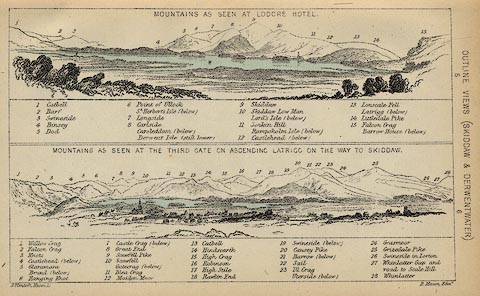 click to enlarge click to enlargeBC08E4.jpg "... 27 Whinlatter Gap and to Scale Hill ..." item:- JandMN : 37.14 Image © see bottom of page |
|||||||||||||
|
|
||||||||||||||
| evidence:- | old print:- Black 1841 (3rd edn 1846) placename:- Whinlatter Gap |
|||||||||||||
| source data:- | Print, engraving, outline view, Mountains as seen at Lowdore Inn, and Mountains as
seen at the Third Gate on Ascending Latrigg on the Way to Skiddaw, by J Flintoft,
Keswick, Cumberland, engraved by R Mason, Edinburgh, Lothian, about 1846.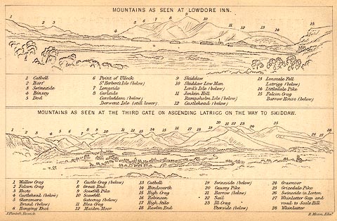 click to enlarge click to enlargeBC02E4.jpg "... 27 Whinlatter Gap and road to Scale Hill ..." item:- JandMN : 32.7 Image © see bottom of page |
|||||||||||||
|
|
||||||||||||||
Lakes Guides menu.