 Old Cumbria Gazetteer
 |
 |
|
| Walna Scar, Dunnerdale-with-Seathwaite | ||
| Walna Scar | ||
| civil parish:- | Dunnerdale-with-Seathwaite (formerly Lancashire) | |
| civil parish:- | Torver (formerly Lancashire) | |
| county:- | Cumbria | |
| locality type:- | hill | |
| coordinates:- | SD256962 (etc) | |
| 1Km square:- | SD2596 | |
| 10Km square:- | SD29 | |
|
|
||
| evidence:- | old map:- Otley 1818 placename:- Walney Scar |
|
| source data:- | Map, uncoloured engraving, The District of the Lakes,
Cumberland, Westmorland, and Lancashire, scale about 4 miles to
1 inch, by Jonathan Otley, 1818, engraved by J and G Menzies,
Edinburgh, Scotland, published by Jonathan Otley, Keswick,
Cumberland, et al, 1833.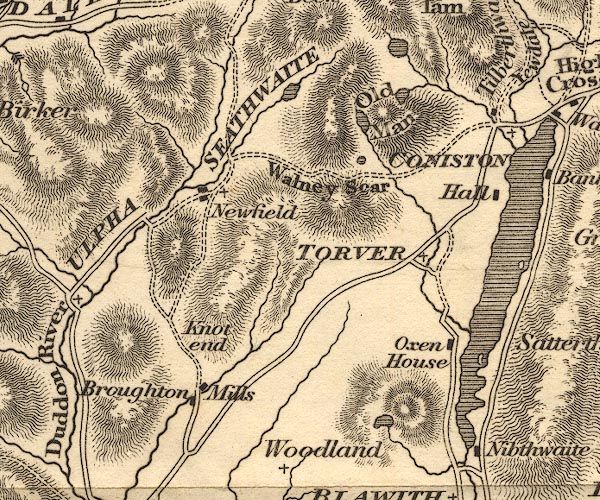 OT02SD29.jpg item:- JandMN : 48.1 Image © see bottom of page |
|
|
|
||
| evidence:- | outline view:- Otley 1823 (8th edn 1849) placename:- Walney Scar |
|
| source data:- | Engraving, outline view of mountains, Coniston Water from near Bank Ground, drawn
by T Binns, engraved by O Jewitt, opposite p.8 of A Descriptive Guide of the English
Lakes, by Jonathan Otley, 8th edition, 1849.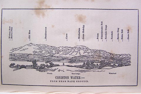 click to enlarge click to enlargeO80E05.jpg item:- Armitt Library : A1180.6 Image © see bottom of page |
|
|
|
||
| evidence:- | outline view:- Aspland 1840s-60s placename:- Walna Scar |
|
| source data:- | Drawing, ink, outline view from Walna Scar, Lancashire, by Theophilus Lindsey Aspland,
about 1852.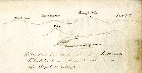 click to enlarge click to enlargeAS0300.jpg "Black Comb / Buckbarrow / [P]lough fell / Hest fell / Pike / Common wood quarries" "Hills seen from Walna Scar over Seathwaite / Black Comb is not seen when near / the chapel or village." item:- Armitt Library : 1958.390.0 Image © see bottom of page |
|
|
|
||
| evidence:- | old map:- Garnett 1850s-60s H placename:- Walney Scar |
|
| source data:- | Map of the English Lakes, in Cumberland, Westmorland and
Lancashire, scale about 3.5 miles to 1 inch, published by John
Garnett, Windermere, Westmorland, 1850s-60s.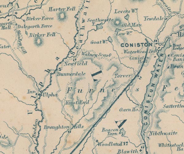 GAR2SD29.jpg "Walney Scar" no symbol item:- JandMN : 82.1 Image © see bottom of page |
|
|
|
||
| evidence:- | outline view:- Jenkinson 1875 placename:- Walney Scar |
|
| source data:- | Print, lithograph, outline view, Panoramic Sketches from Scawfell Pike, Cumberland,
by Edwin A Pettitt, London, published by Edward Stanford, 55 Charing Cross, London,
1875. click to enlarge click to enlargeJk01E3.jpg "... Walney Scar ..." item:- JandMN : 28.9 Image © see bottom of page |
|
|
|
||
| evidence:- | outline view:- Black 1856 (23rd edn 1900) placename:- Walney Scar |
|
| source data:- | Print, lithograph, Outline Views, Grasmere and Coniston - Mountains as seen from Redbank,
Grasmere, and Mountains as seen a little beyond Tent Lodge on the Road from Coniston
to Ulverstone, by J Flintoft, Keswick, Cumberland, engraved by R Mason, Edinburgh,
Lothian, about 1900.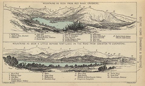 click to enlarge click to enlargeBC08E3.jpg "... 2 Walney Scar ..." item:- JandMN : 37.12 Image © see bottom of page |
|
|
|
||
| evidence:- | outline view:- Black 1841 (3rd edn 1846) placename:- Walney Scar |
|
| source data:- | Print, engraving, outline view, Mountains as seen from Red Bank, Grasmere, and Mountains
as seen a little beyond Tent-Lodge on the Road from Coniston to Ulverston, by J Flintoft,
Keswick, Cumberland, engraved by R Mason, Edinburgh, Lothian, about 1846.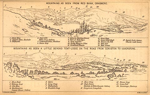 click to enlarge click to enlargeBC02E3.jpg "... 2 Walney Scar ..." item:- JandMN : 32.5 Image © see bottom of page |
|
|
|
||
 Lakes Guides menu.