 Old Cumbria Gazetteer
 |
 |
|
| Triermain Castle, Waterhead | ||
| Triermain Castle | ||
| locality:- | Triermain | |
| civil parish:- | Waterhead (formerly Cumberland) | |
| county:- | Cumbria | |
| locality type:- | castle | |
| locality type:- | earthwork | |
| locality type:- | pele tower (?) | |
| coordinates:- | NY59476680 | |
| 1Km square:- | NY5966 | |
| 10Km square:- | NY56 | |
|
|
||
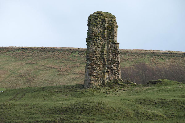 BOW20.jpg Not a lot left. (taken 21.3.2008) |
||
|
|
||
| evidence:- | old map:- OS County Series (Cmd 12 7) |
|
| source data:- | Maps, County Series maps of Great Britain, scales 6 and 25
inches to 1 mile, published by the Ordnance Survey, Southampton,
Hampshire, from about 1863 to 1948. "Tryermain / Castle (Remains of)" |
|
|
|
||
| evidence:- | text:- Curwen 1913 placename:- Treuermane item:- licence to crenellate |
|
| source data:- | Book, The Castles and Fortified Towers of Cumberland,
Westmorland, and Lancashire North of the Sands, by John F
Curwen, published for the Cumberland and Westmorland Antiquarian
and Archaeological Society by Titus Wilson, Kendal, Westmorland,
1913. Licence to crenellate granted by Edward III; 4 February 1340:- "Robertus de Vaux ... mansum suum ... Treuermane in Marchi' Scotiae" |
|
|
|
||
| evidence:- | text:- Jackson 1990 placename:- Trevermane castle placename:- Trivermain castle placename:- Tradermayne Castle placename:- Tridermaine castle |
|
| source data:- | ||
|
|
||
| hearsay:- |
Roland de Vaux had a licence to crenellate, 1340. |
|
|
|
||
| notes:- |
tower, gateway, curtain wall, moat, all in ruins |
|
| Perriam, D R &Robinson, J: 1998: Medieval Fortified Buildings of Cumbria: CWAAS::
ISBN 1 873124 23 6; plan and illustration |
||
|
|
||
 Lakes Guides menu.