 Old Cumbria Gazetteer
 |
 |
|
| Thornthwaite Mine, Thornthwaite | ||
| Thornthwaite Mine | ||
| Thornthwaite Mines | ||
| locality:- | Thornthwaite | |
| civil parish:- | Above Derwent (formerly Cumberland) | |
| county:- | Cumbria | |
| locality type:- | zinc mine | |
| locality type:- | lead mine | |
| locality type:- | mine | |
| coordinates:- | NY22342577 (about) | |
| 1Km square:- | NY2225 | |
| 10Km square:- | NY22 | |
| references:- | Adams, John: 1988: Mines of the Lake District Fells: Dalesman Books (Lancaster, Lancashire)::
ISBN 0 85206 931 6 |
|
|
|
||
| evidence:- | old map:- OS County Series (Cmd 55 16) |
|
| source data:- | Maps, County Series maps of Great Britain, scales 6 and 25
inches to 1 mile, published by the Ordnance Survey, Southampton,
Hampshire, from about 1863 to 1948. "Old Lead Mine" |
|
|
|
||
| evidence:- | old text:- Clarke 1787 |
|
| source data:- | Guide book, A Survey of the Lakes of Cumberland, Westmorland,
and Lancashire, written and published by James Clarke, Penrith,
Cumberland, and in London etc, 1787; published 1787-93. goto source goto sourcePage 92:- "..." "There are at present a few men employed in the lead mines close to the road. These mines have no particular names that I know of, but are near places called Jenkin Hill and Walker Yates; they have been only lately discovered, and are not valuable. ..." |
|
|
|
||
| evidence:- | presumably old print:- Wilkinson 1810 (plate 37) |
|
| source data:- | Print, uncoloured soft ground etching, Smelting Mill, near Thornthwaite, Cumberland,
by Joseph Wilkinson, engraved by William Frederick Wells, published by R Ackermann,
Repository of Arts, 101 Strand, London, 1810.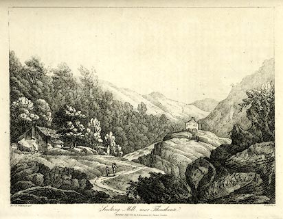 click to enlarge click to enlargeWKN137.jpg Plate 37 in Select Views in Cumberland, Westmoreland, and Lancashire. printed at bottom left, right, centre:- "Revd. Jos: Wilkenson delt. / W. F. Wells sc. / Smelting Mill, near Thornthwaite. / Published July 1. 1810. by R. Ackermann. 101. Strand. London." item:- Fell and Rock Climbing Club : MN4.37 Image © see bottom of page |
|
|
|
||
| evidence:- | old text:- Postlethwaite 1877 (3rd edn 1913) placename:- Thornthwaite Mines item:- lead ore; galena; cerussite; blende; iron pyrites; Ladstock Mine, Above Derwent; Rachel Wood Mine, Thornthwaite; Beckstones Mine, Above Derwent; water wheel; steam engine; rock drill; gas engine; pelton wheel |
|
| source data:- | Book, Mines and Mining in the English Lake District, by John Postlethwaite, Keswick,
published by W H Moss and Sons, Whitehaven, Cumberland now Cumbria, 1877; published
1877-1913. goto source page 91:- "THE THORNTHWAITE MINES." "In the Township of Thornthwaite, about four-and-a-half miles north of Yewthwaite, and two-and-a-half miles north of Barrow Mine, and in the direct course of the vein, there is a very valuable mining field. It embraces seven large veins, four of which are nearly due north and south, and one a few degrees west of north and east of south; the remaining two are contra veins, or cross courses, running north-east and south-west." "There are some small thin dykes, or sheets of intrusive trap (diorite?) which intersect and no doubt enrich the veins." "The ores found in these veins are galena, cerussite, blende, and iron pyrites." "Four distinct mines have been opened on the veins, namely, Ladstock, Rachel Wood, Thornthwaite, and Beckstones; they have been wrought chiefly by means of adit levels and pits sunk on the backs of the veins, except Thornthwaite Mine, where a shaft was sunk to a depth of 27 fathoms, about eighty or ninety years ago." goto sourcepage 93:- "A great deal of ground has been excavated, and a large quantity of ore raised from these mines; sufficient, in fact, to warrant the erection of smelting works, which were used as late as 1849. Ladstock is the oldest mine, having been wrought to some extent before the use of gunpowder was known." "In 1848, Thornthwaite Mine was re-opened by the Keswick Mining Co., who erected a 40-feet water wheel to pump the water from the mine, sunk the shaft 10 fathoms, and raised a considerable quantity of galena. They also obtained some ore by re-washing the refuse of the old miners in Beckstones Gill, but their work did not extend over more than five or six years." "In 1873, these mines were again taken up by Mr. W. Francis, who re-opened Ladstock Mine, and obtained some ore. A Company was then formed, called "The Keswick United Silver Lead Mine Co." a portable 30-horse power steam engine procured, and Thornthwaite Mine was re-opened, but owing to lack of capital these operations were not conducted in a very energetic manner." "In 1881, the property was transferred to Mr. J. B. Lobb, a new company was formed, called "The Cumberland Lead Mine Co." by whom the machinery and plant was largely increased, and put into an efficient state for the more rapid development of the mine. The 30-horse power steam engine was then used for drawing, and for pumping there was a 36-feet water wheel, attached to a 40-horse power steam engine. The ore was broken by a Marsden stone breaker and crushing mill, and separated by Green's and Thomas's dressing machines. The slimes were dressed in circular buddles. The machinery was propelled by a 30-feet water wheel, assisted by a 20-horse power steam engine." "Four rock drills were in use in the mine for the purpose of opening up new ground more rapidly; they were propelled by compressed air supplied by a small steam engine at the head of the shaft." "The shaft was sunk to a depth of 50 fathoms, the 17, 27, and 37-fathom levels were extended a considerable distance southwards, and a good deal of ore stoped out." "After the death of Mr. Lobb, who was the leading member of the firm, the mine passed into the hands of Messrs. F. W. Crewdson and Anthony Wilson, who formed the Company now working the mine under the title of "Thornthwaite Mines Ltd." Under this Company the shaft has been sunk first to 65 fathoms, where levels were again driven off northward 168 and southward 305 fathoms. The 17-fathom level has been extended north 170 and south 190 fathoms. The 37-fathom level north 150 and south 175 fathoms, while the 47-fathom level has been driven north about 140 and south 155 fathoms." "The shaft is now again (November, 1912) being sunk to a depth of 85 fathoms and new pumps will be installed that will be" goto sourcepage 94:- "capable of lifting 350 gallons per minute, and sufficiently powerful to go down to 105 fathoms. They will consist of a 13-in. ram to lift the water from the bottom to the 65 level, and a 15-in. ram there to lift it to the surface." "The power required for pumping, drawing and dressing is supplied primarily from Ladstock Beck, and a reservoir on Whinlatter, which has a storage capacity of 1,000,000 gallons, and which gives a head for pressure at the shaft top of 500 feet." "The motive power for the pumps consists of a Hydraulic Bull Engine, working one 10-in. and one 12-in. ram." "The dressing machinery is driven by a Pelton Wheel, 45-horse-power, assisted in dry times by a Suction Gas Plant, 45-horse-power. The Slime Plant is driven by an 8-horse-power Pelton Wheel." "The hauling or drawing is done by a 30-horse-power Robey Engine." "The dressing plant consists of two Blake Marsden Stone Breakers, two sets of Luhrig high-speed Crushing Rolls, by which the crude ore is reduced to 4m.m. or 3/16ths of an inch. It is then treated on Green's Luhrig, and Davison's Jiggers. The slime dressing plant consists of four Wilfley Tables, one Burs Table, two Luhrig Slimers, and one Luhrig Vanner." 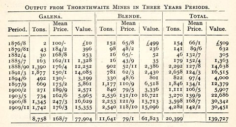 click to enlarge click to enlargePST3Tab4.jpg "The number of men employed in the mine and on the surface is about 90, and the average during 35 years represented in the above output will not be far below that number." |
|
|
|
||
| evidence:- | old map:- Postlethwaite 1877 (3rd edn 1913) placename:- Thornthwaite Mine |
|
| source data:- | Map, uncoloured engraving, Map of the Lake District Mining Field, Westmorland, Cumberland,
Lancashire, scale about 5 miles to 1 inch, by John Postlethwaite, published by W H
Moss and Sons, 13 Lowther Street, Whitehaven, Cumberland, 1877 edn 1913.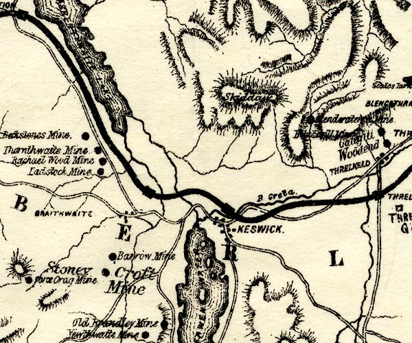 PST2NY22.jpg "Thornthwaite Mine" mine symbol item:- JandMN : 162.2 Image © see bottom of page |
|
|
|
||
| evidence:- | mine plan:- Postlethwaite 1877 placename:- Thornthwaite Mine |
|
| source data:- | Print, drawing, mine sections, Section of Thornthwaite Mine, Above Derwent, Cumberland,
scale about 1 to 2900, by J W Anderson, 1909, published by W H Moss and Sons, 13 Lowther
Street, Whitehaven, Cumberland, 1877 edn 1913.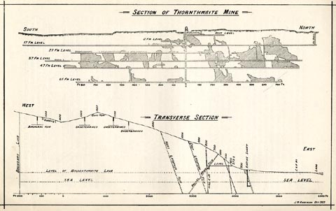 click to enlarge click to enlargePST318.jpg On p.92 of Mines and Mining in the English Lake District, by John Postlethwaite. printed, upper centre "SECTION OF THORNTHWAITE MINE." printed, lower right "J. W. ANDERSON OCT 1909" item:- JandMN : 162.20 Image © see bottom of page |
|
|
|
||
| evidence:- | old text:- Postlethwaite 1877 (3rd edn 1913) placename:- Thornthwaite Mines item:- lead ore; galena; cerussite; blende; iron pyrites; Ladstock Mine, Above Derwent; Rachel Wood Mine, Thornthwaite; Beckstones Mine, Above Derwent; water wheel; steam engine; rock drill; gas engine; pelton wheel |
|
| source data:- | Book, Mines and Mining in the English Lake District, by John Postlethwaite, Keswick,
published by W H Moss and Sons, Whitehaven, Cumberland now Cumbria, 1877; published
1877-1913. goto source page 91:- "THE THORNTHWAITE MINES." "In the Township of Thornthwaite, about four-and-a-half miles north of Yewthwaite, and two-and-a-half miles north of Barrow Mine, and in the direct course of the vein, there is a very valuable mining field. It embraces seven large veins, four of which are nearly due north and south, and one a few degrees west of north and east of south; the remaining two are contra veins, or cross courses, running north-east and south-west." "There are some small thin dykes, or sheets of intrusive trap (diorite?) which intersect and no doubt enrich the veins." "The ores found in these veins are galena, cerussite, blende, and iron pyrites." "Four distinct mines have been opened on the veins, namely, Ladstock, Rachel Wood, Thornthwaite, and Beckstones; they have been wrought chiefly by means of adit levels and pits sunk on the backs of the veins, except Thornthwaite Mine, where a shaft was sunk to a depth of 27 fathoms, about eighty or ninety years ago." goto sourcepage 93:- "A great deal of ground has been excavated, and a large quantity of ore raised from these mines; sufficient, in fact, to warrant the erection of smelting works, which were used as late as 1849. Ladstock is the oldest mine, having been wrought to some extent before the use of gunpowder was known." "In 1848, Thornthwaite Mine was re-opened by the Keswick Mining Co., who erected a 40-feet water wheel to pump the water from the mine, sunk the shaft 10 fathoms, and raised a considerable quantity of galena. They also obtained some ore by re-washing the refuse of the old miners in Beckstones Gill, but their work did not extend over more than five or six years." "In 1873, these mines were again taken up by Mr. W. Francis, who re-opened Ladstock Mine, and obtained some ore. A Company was then formed, called "The Keswick United Silver Lead Mine Co." a portable 30-horse power steam engine procured, and Thornthwaite Mine was re-opened, but owing to lack of capital these operations were not conducted in a very energetic manner." "In 1881, the property was transferred to Mr. J. B. Lobb, a new company was formed, called "The Cumberland Lead Mine Co." by whom the machinery and plant was largely increased, and put into an efficient state for the more rapid development of the mine. The 30-horse power steam engine was then used for drawing, and for pumping there was a 36-feet water wheel, attached to a 40-horse power steam engine. The ore was broken by a Marsden stone breaker and crushing mill, and separated by Green's and Thomas's dressing machines. The slimes were dressed in circular buddles. The machinery was propelled by a 30-feet water wheel, assisted by a 20-horse power steam engine." "Four rock drills were in use in the mine for the purpose of opening up new ground more rapidly; they were propelled by compressed air supplied by a small steam engine at the head of the shaft." "The shaft was sunk to a depth of 50 fathoms, the 17, 27, and 37-fathom levels were extended a considerable distance southwards, and a good deal of ore stoped out." "After the death of Mr. Lobb, who was the leading member of the firm, the mine passed into the hands of Messrs. F. W. Crewdson and Anthony Wilson, who formed the Company now working the mine under the title of "Thornthwaite Mines Ltd." Under this Company the shaft has been sunk first to 65 fathoms, where levels were again driven off northward 168 and southward 305 fathoms. The 17-fathom level has been extended north 170 and south 190 fathoms. The 37-fathom level north 150 and south 175 fathoms, while the 47-fathom level has been driven north about 140 and south 155 fathoms." "The shaft is now again (November, 1912) being sunk to a depth of 85 fathoms and new pumps will be installed that will be" goto sourcepage 94:- "capable of lifting 350 gallons per minute, and sufficiently powerful to go down to 105 fathoms. They will consist of a 13-in. ram to lift the water from the bottom to the 65 level, and a 15-in. ram there to lift it to the surface." "The power required for pumping, drawing and dressing is supplied primarily from Ladstock Beck, and a reservoir on Whinlatter, which has a storage capacity of 1,000,000 gallons, and which gives a head for pressure at the shaft top of 500 feet." "The motive power for the pumps consists of a Hydraulic Bull Engine, working one 10-in. and one 12-in. ram." "The dressing machinery is driven by a Pelton Wheel, 45-horse-power, assisted in dry times by a Suction Gas Plant, 45-horse-power. The Slime Plant is driven by an 8-horse-power Pelton Wheel." "The hauling or drawing is done by a 30-horse-power Robey Engine." "The dressing plant consists of two Blake Marsden Stone Breakers, two sets of Luhrig high-speed Crushing Rolls, by which the crude ore is reduced to 4m.m. or 3/16ths of an inch. It is then treated on Green's Luhrig, and Davison's Jiggers. The slime dressing plant consists of four Wilfley Tables, one Burs Table, two Luhrig Slimers, and one Luhrig Vanner." click to enlargePST3Tab4.jpg "The number of men employed in the mine and on the surface is about 90, and the average during 35 years represented in the above output will not be far below that number." |
|
|
|
||
| evidence:- | old map:- Postlethwaite 1877 (3rd edn 1913) placename:- Thornthwaite Mine |
|
| source data:- | Map, uncoloured engraving, Map of the Lake District Mining Field, Westmorland, Cumberland,
Lancashire, scale about 5 miles to 1 inch, by John Postlethwaite, published by W H
Moss and Sons, 13 Lowther Street, Whitehaven, Cumberland, 1877 edn 1913. PST2NY22.jpg "Thornthwaite Mine" mine symbol item:- JandMN : 162.2 Image © see bottom of page |
|
|
|
||
| evidence:- | mine plan:- Postlethwaite 1877 placename:- Thornthwaite Mine |
|
| source data:- | Print, drawing, mine sections, Section of Thornthwaite Mine, Above Derwent, Cumberland,
scale about 1 to 2900, by J W Anderson, 1909, published by W H Moss and Sons, 13 Lowther
Street, Whitehaven, Cumberland, 1877 edn 1913. click to enlarge PST318.jpg On p.92 of Mines and Mining in the English Lake District, by John Postlethwaite. printed, upper centre "SECTION OF THORNTHWAITE MINE." printed, lower right "J. W. ANDERSON OCT 1909" item:- JandMN : 162.20 Image © see bottom of page |
|
|
|
||
| evidence:- | mine drawing:- KDMRS 1979-82 placename:- Thornthwaite Mine |
|
| source data:- | Geological Outing of the Kendal and District Mine Research Society to Thornthwaite
Mine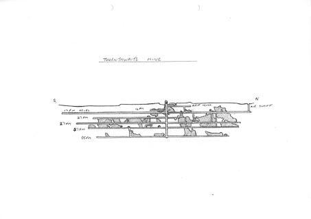 click to enlarge click to enlargeKMR38.jpg "THORNTHWAITE MINE" item:- private collection : 82 Image © see bottom of page |
|
|
|
||
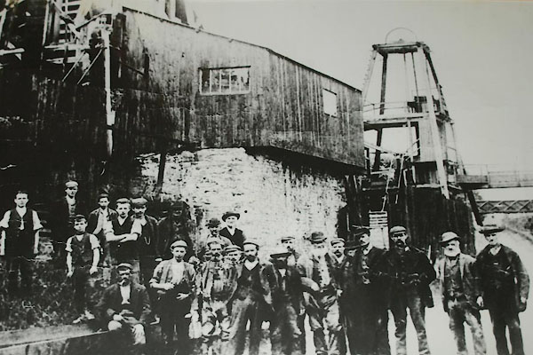 BXQ75.jpg (taken 16.11.2012) courtesy of the Royal Oak, Braithwaite |
||
|
|
||
| :- |
Thornthwaite Lode a northern extension of the Yewthwaite Lode and Barrow Lode, argentiferous
galena and blende, with cerussite, gossan. |
|
| Adams, John: 1988: Mines of the Lake District Fells: Dalesman Books (Lancaster, Lancashire)::
ISBN 0 85206 931 6 |
||
|
|
||
Lakes Guides menu.