 Old Cumbria Gazetteer
 |
 |
|
| Thorney Pot, North Yorkshire | ||
| Thorney Pot | ||
| site name:- | Gragareth | |
| county:- | North Yorkshire | |
| locality type:- | pothole | |
| locality type:- | cave | |
| coordinates:- | SD695773 | |
| 1Km square:- | SD6977 | |
| 10Km square:- | SD67 | |
| altitude:- | 1220 feet | |
| altitude:- | 372m | |
| SummaryText:- | Grade I; permission from Thornton Hall, Westhouse. | |
| references:- | Balderston c1890 Brook, D & Davies, G & Long, M H &Sutcliffe, J R: 1975: Northern Caves, vol.4 Whernside and Gragareth: Dalesman Books:: ISBN 0 85206 259 1 |
|
|
|
||
| evidence:- | descriptive text:- Balderston c1890 placename:- Thorney Pot |
|
| source data:- | Book, Ingleton, Bygone and Present, by Robert R and Margaret
Balderston, published by Simpkin, Marshall and Co, London, and
by Edmndson and Co, 24 High Street, Skipton, Yorkshire, about
1890. goto source goto sourcepage 64:- "..." "Swinsto Hole, Shake Holes, and Thorney Pot." "Returning along the scar to the south of Rowantree Cave, ... Thorney Pot a little to the south [of Swinsto Hole], and in a direct line with the Scales" goto sourcepage 65:- "[Scales] Moor wall, is thirty-two feet deep, and the cellar at the northern corner descends eighteen feet further." |
|
|
|
||
| evidence:- | old map:- Balderston c1890 map placename:- Thorney Pot |
|
| source data:- | Map, the hills in the Ingleton area, probably by Robert R
Balderston, engraved by Goodall and Suddick, Leeds, West
Yorkshire, about 1890.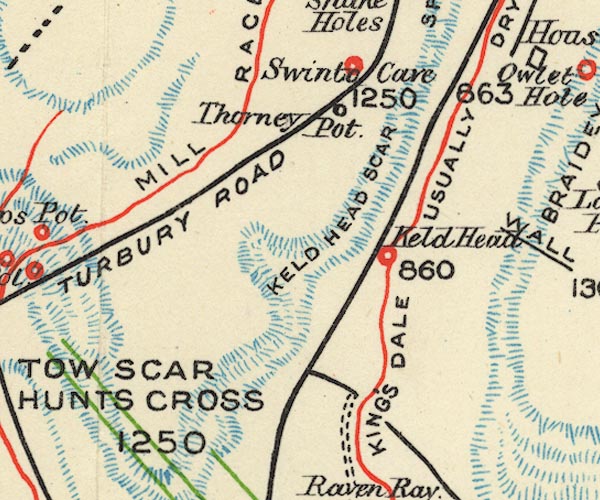 BS1SD67Y.jpg "Thorney Pot" item:- private collection : 27.1 Image © see bottom of page |
|
|
|
||
Lakes Guides menu.