 Old Cumbria Gazetteer
 |
 |
|
| Tatham Wife Hole, North Yorkshire | ||
| Tatham Wife Hole | ||
| county:- | North Yorkshire | |
| locality type:- | cave | |
| locality type:- | pothole | |
| coordinates:- | SD731747 | |
| 1Km square:- | SD7374 | |
| 10Km square:- | SD77 | |
| SummaryText:- | Grade III. | |
| SummaryText:- | Explored by Earby Pothole Club, 1967; extended by University of Leeds Speleological Association, 1972. | |
| references:- | Brook, A & Brook, D & Davies, G M &Long, M H: 1975: Northern Caves, vol.3 Ingleborough:
Dalesman Books (Clapham, North Yorkshire):: ISBN 0 85206 312 1 |
|
|
|
||
| evidence:- | descriptive text:- Balderston c1890 placename:- Tatham Wife Hole |
|
| source data:- | Book, Ingleton, Bygone and Present, by Robert R and Margaret
Balderston, published by Simpkin, Marshall and Co, London, and
by Edmndson and Co, 24 High Street, Skipton, Yorkshire, about
1890. goto source goto sourcepage 75:- "..." "... there are many funnel-shaped holes on the moorland not far above Crina Bottom. ... Tatham Wife Hole is near the bottom of Foal's Foot, to the west of the summit - a couple of conjoined holes one hundred and fourteen yards round and fifty-two feet up the highest slope. ..." |
|
|
|
||
| evidence:- | old map:- Balderston c1890 map placename:- Tatham Wife Shakehole |
|
| source data:- | Map, the hills in the Ingleton area, probably by Robert R
Balderston, engraved by Goodall and Suddick, Leeds, West
Yorkshire, about 1890.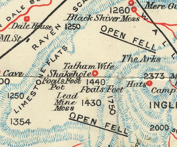 BS1SD77H.jpg "Tatham Wife Shakehole" item:- private collection : 27.1 Image © see bottom of page |
|
|
|
||
Lakes Guides menu.